Pereyaslovskaya geodata
Pereyaslovskaya (Krasnodarskiy) is a populated place; located in Russia in Europe/Moscow (GMT+3) time zone. With population of 8,542 people, there are 1714 cities with bigger population in this country. Compared to other cities in Russia, 84.6% of cities are located further ↑North; 72.1% of cities are located further →East and 92.2% of cities have higher elevation than Pereyaslovskaya. Note1


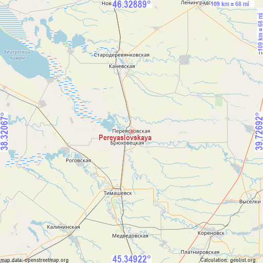
Pereyaslovskaya GPS coordinates[2]
45° 50' 28.356" North, 39° 1' 25.644" East
| Map corner | latitude | longitude |
|---|---|---|
| Upper-left | 46.32889°, | 38.32067° |
| Center: | 45.84121°, | 39.02379° |
| Lower-right: | 45.34922°, | 39.72692° |
| Map W x H: | 108.9×108.9 km | = 67.7×67.7mi |
| max Lat: | 73.50819° ⇑84.6% North |
| Pereyaslovskaya: | 45.84121° |
| min Lat: | ⇓15.4% South 41.28413° |
| min Long | Pereyaslovskaya | max Long |
| -179.12198° | 39.02379° | 179.35046° |
| W 27.9%⇐ | ⇒72.1% E |
Elevation
Elevation of Pereyaslovskaya is 21 m = 69 ft, and this is 181.6 m = 596 ft below average elevation for this country.
| Max E: |
2518 m = 8261 ft | 92.2% |
| Avg. | 202.6 m = 665 ft | |
| Pereyaslovskaya | 21 m = 69 ft | |
Min E: |
-28 m = -92 ft | 7.8% |
See also: Russia elevation on elevation.city.
Geographical zone
Pereyaslovskaya is located in North temperate zone (between Tropic of Cancer and the Arctic Circle). Distance of this North polar circle is 2304.1 km =1431.7 mi to North.| Distance of | km | miles | from Pereyaslovskaya |
|---|---|---|---|
| North Pole | 4910 | 3050.9 | to North |
| Arctic Circle | 2304.1 | 1431.7 | to North |
| Tropic Cancer | 2491.1 | 1547.9 | to South |
| Equator | 5097.1 | 3167.2 | to South |


Nearby cities:
15 places around Pereyaslovskaya: (largest is in red/bold)
• Baturinskaya
27.4 km =17 mi,  101°
101°
• Berezanskaya
46.7 km =29 mi,  108°
108°
• Bryukhovetskaya
4.3 km =2.7 mi,  205°
205°
• Chelbasskaya
31 km =19.3 mi,  60°
60°
• Dneprovskaya
29.4 km =18.3 mi, 214°
• Kanevskaya
27.5 km =17.1 mi,  349°
349°
• Krylovskaya
36.9 km =22.9 mi,  35°
35°
• Medvedovskaya
43.3 km =26.9 mi,  179°
179°
• Novodzhereliyevskaya
28.3 km =17.6 mi,  254°
254°
• Novokorsunskaya
24.2 km =15 mi,  156°
156°
• Novoplatnirovskaya
42.5 km =26.4 mi,  46°
46°
• Ol’ginskaya
38.6 km =24 mi,  287°
287°
• Rogovskaya
25.2 km =15.7 mi,  240°
240°
• Staroderevyankovskaya
32.1 km =19.9 mi, 352°
• Timashëvsk
25.7 km =16 mi,  193°
193°
Sources, notices
• [Note1] Compared only with cities in Russia existing in our database
• [Src1] Map data: © OpenStreetMap contributors (CC-BY-SA)
• [Src2] Other city data from geonames.org with taken over terms of usage.
• [Src3] Geographical zone / Annual Mean Temperature by Robert A. Rohde @ Wikipedia
