Zalegoshch’ geodata
Zalegoshch’ (Orel Oblast) is a populated place; located in Russia in Europe/Moscow (GMT+3) time zone. With population of 5,925 people, there are 2285 cities with bigger population in this country. Compared to other cities in Russia, 63.4% of cities are located further ↑North; 85.1% of cities are located further →East and 73.5% of cities have lower elevation than Zalegoshch’. Note1


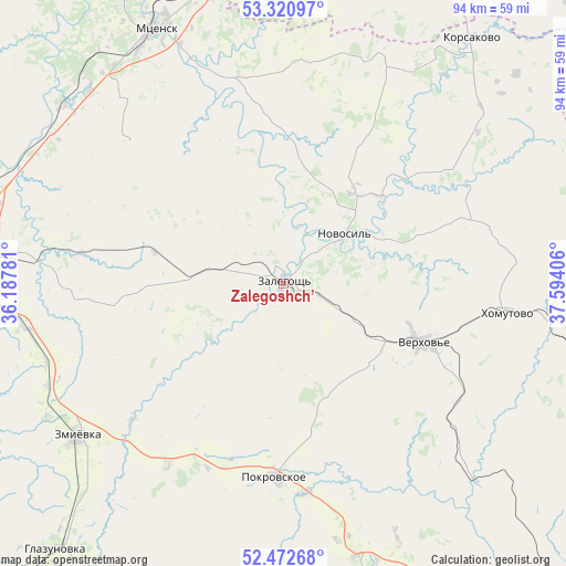
Zalegoshch’ GPS coordinates[2]
52° 53' 56.04" North, 36° 53' 27.348" East
| Map corner | latitude | longitude |
|---|---|---|
| Upper-left | 53.32097°, | 36.18781° |
| Center: | 52.8989°, | 36.89093° |
| Lower-right: | 52.47268°, | 37.59406° |
| Map W x H: | 94.3×94.3 km | = 58.6×58.6mi |
| max Lat: | 73.50819° ⇑63.4% North |
| Zalegoshch’: | 52.8989° |
| min Lat: | ⇓36.6% South 41.28413° |
| min Long | Zalegoshch’ | max Long |
| -179.12198° | 36.89093° | 179.35046° |
| W 14.9%⇐ | ⇒85.1% E |
Elevation
Elevation of Zalegoshch’ is 210 m = 689 ft, and this is 7.4 m = 24 ft above average elevation for this country.
| Max E: |
2518 m = 8261 ft | 26.5% |
| Zalegoshch’ | 210 m 689 ft | |
| Avg. | 202.6 m = 665 ft | |
Min E: |
-28 m = -92 ft | 73.5% |
See also: Russia elevation on elevation.city.
Geographical zone
Zalegoshch’ is located in North temperate zone (between Tropic of Cancer and the Arctic Circle). Distance of this North polar circle is 1519.4 km =944.1 mi to North.| Distance of | km | miles | from Zalegoshch’ |
|---|---|---|---|
| North Pole | 4125.3 | 2563.3 | to North |
| Arctic Circle | 1519.4 | 944.1 | to North |
| Tropic Cancer | 3275.9 | 2035.5 | to South |
| Equator | 5881.8 | 3654.8 | to South |


Nearby cities:
15 places around Zalegoshch’: (largest is in red/bold)
• Bol’shoye Skuratovo
60.1 km =37.3 mi,  356°
356°
• Chern’
61.6 km =38.3 mi,  1°
1°
• Glazunovka
58.7 km =36.5 mi,  220°
220°
• Khomutovo
37.1 km =23.1 mi,  97°
97°
• Korsakovo
51.5 km =32 mi,  37°
37°
• Krasnaya Zarya
54.6 km =33.9 mi, 103°
• Maloarkhangel’sk
61.3 km =38.1 mi,  205°
205°
• Mtsensk
47 km =29.2 mi,  333°
333°
• Novosil’
13 km =8.1 mi,  50°
50°
• Orël
54.9 km =34.1 mi,  277°
277°
• Pokrovskoye
32.2 km =20 mi,  182°
182°
• Spasskoye-Lutovinovo
55.4 km =34.4 mi,  341°
341°
• Verkhov’ye
25.5 km =15.8 mi,  112°
112°
• Zmiyëvka
43.3 km =26.9 mi,  233°
233°
• Znamenka
61.3 km =38.1 mi,  269°
269°
Sources, notices
• [Note1] Compared only with cities in Russia existing in our database
• [Src1] Map data: © OpenStreetMap contributors (CC-BY-SA)
• [Src2] Other city data from geonames.org with taken over terms of usage.
• [Src3] Geographical zone / Annual Mean Temperature by Robert A. Rohde @ Wikipedia
