Shvartsevskiy geodata
Shvartsevskiy (Tula) is a populated place; located in Russia in Europe/Moscow (GMT+3) time zone. With population of 5,083 people, there are 2620 cities with bigger population in this country. Compared to other cities in Russia, 54.5% of cities are located further ↑North; 77.4% of cities are located further →East and 77.5% of cities have lower elevation than Shvartsevskiy. Note1


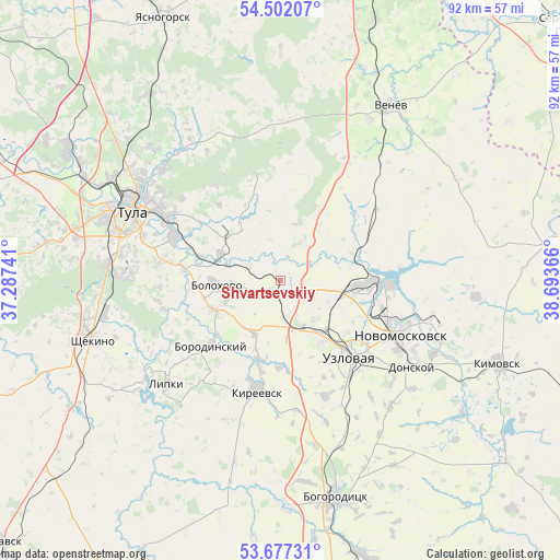
Shvartsevskiy GPS coordinates[2]
54° 5' 30.264" North, 37° 59' 25.908" East
| Map corner | latitude | longitude |
|---|---|---|
| Upper-left | 54.50207°, | 37.28741° |
| Center: | 54.09174°, | 37.99053° |
| Lower-right: | 53.67731°, | 38.69366° |
| Map W x H: | 91.7×91.7 km | = 57×57mi |
| max Lat: | 73.50819° ⇑54.5% North |
| Shvartsevskiy: | 54.09174° |
| min Lat: | ⇓45.5% South 41.28413° |
| min Long | Shvartsevskiy | max Long |
| -179.12198° | 37.99053° | 179.35046° |
| W 22.6%⇐ | ⇒77.4% E |
Elevation
Elevation of Shvartsevskiy is 229 m = 751 ft, and this is 26.4 m = 87 ft above average elevation for this country.
| Max E: |
2518 m = 8261 ft | 22.5% |
| Shvartsevskiy | 229 m 751 ft | |
| Avg. | 202.6 m = 665 ft | |
Min E: |
-28 m = -92 ft | 77.5% |
See also: Russia elevation on elevation.city.
Geographical zone
Shvartsevskiy is located in North temperate zone (between Tropic of Cancer and the Arctic Circle). Distance of this North polar circle is 1386.7 km =861.7 mi to North.| Distance of | km | miles | from Shvartsevskiy |
|---|---|---|---|
| North Pole | 3992.6 | 2480.9 | to North |
| Arctic Circle | 1386.7 | 861.7 | to North |
| Tropic Cancer | 3408.5 | 2117.9 | to South |
| Equator | 6014.4 | 3737.2 | to South |


Nearby cities:
15 places around Shvartsevskiy: (largest is in red/bold)
• Bolokhovo
10.6 km =6.6 mi,  265°
265°
• Borodinskiy
15.3 km =9.5 mi,  227°
227°
• Brusyanka
12.2 km =7.6 mi,  165°
165°
• Dubovka
16.2 km =10.1 mi,  163°
163°
• Gritsovskiy
12.2 km =7.6 mi,  65°
65°
• Kamenetskiy
17.4 km =10.8 mi,  120°
120°
• Kireyevsk
18.1 km =11.2 mi,  193°
193°
• Lomintsevskiy
24.3 km =15.1 mi,  240°
240°
• Mayskiy
20.4 km =12.7 mi,  134°
134°
• Novomoskovsk
21.2 km =13.2 mi, 115°
• Partizan
17.2 km =10.7 mi, 155°
• Podlesnyy
24.8 km =15.4 mi, 132°
• Priupskiy
26.2 km =16.3 mi,  219°
219°
• Skuratovskiy
25.2 km =15.7 mi, 272°
• Uzlovaya
17 km =10.6 mi,  136°
136°
Sources, notices
• [Note1] Compared only with cities in Russia existing in our database
• [Src1] Map data: © OpenStreetMap contributors (CC-BY-SA)
• [Src2] Other city data from geonames.org with taken over terms of usage.
• [Src3] Geographical zone / Annual Mean Temperature by Robert A. Rohde @ Wikipedia
