Mayskiy geodata
Mayskiy (Tula) is a populated place; located in Russia in Europe/Moscow (GMT+3) time zone. With population of 2,055 people, there are 4129 cities with bigger population in this country. Compared to other cities in Russia, 55.6% of cities are located further ↑North; 75.8% of cities are located further →East and 76.6% of cities have lower elevation than Mayskiy. Note1


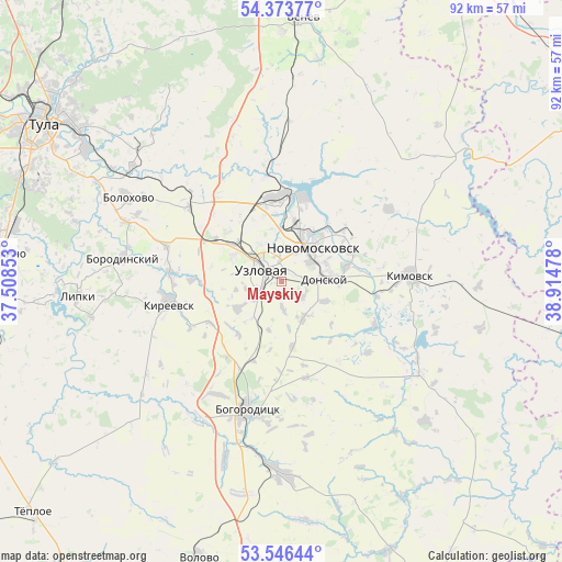
Mayskiy GPS coordinates[2]
53° 57' 43.776" North, 38° 12' 41.94" East
| Map corner | latitude | longitude |
|---|---|---|
| Upper-left | 54.37377°, | 37.50853° |
| Center: | 53.96216°, | 38.21165° |
| Lower-right: | 53.54644°, | 38.91478° |
| Map W x H: | 92×92 km | = 57.2×57.2mi |
| max Lat: | 73.50819° ⇑55.6% North |
| Mayskiy: | 53.96216° |
| min Lat: | ⇓44.4% South 41.28413° |
| min Long | Mayskiy | max Long |
| -179.12198° | 38.21165° | 179.35046° |
| W 24.2%⇐ | ⇒75.8% E |
Elevation
Elevation of Mayskiy is 224 m = 735 ft, and this is 21.4 m = 70 ft above average elevation for this country.
| Max E: |
2518 m = 8261 ft | 23.4% |
| Mayskiy | 224 m 735 ft | |
| Avg. | 202.6 m = 665 ft | |
Min E: |
-28 m = -92 ft | 76.6% |
See also: Russia elevation on elevation.city.
Geographical zone
Mayskiy is located in North temperate zone (between Tropic of Cancer and the Arctic Circle). Distance of this North polar circle is 1401.1 km =870.6 mi to North.| Distance of | km | miles | from Mayskiy |
|---|---|---|---|
| North Pole | 4007 | 2489.8 | to North |
| Arctic Circle | 1401.1 | 870.6 | to North |
| Tropic Cancer | 3394.1 | 2109 | to South |
| Equator | 6000 | 3728.2 | to South |


Nearby cities:
15 places around Mayskiy: (largest is in red/bold)
• Begichevskiy
18.7 km =11.6 mi,  171°
171°
• Bogoroditsk
21.9 km =13.6 mi,  195°
195°
• Brusyanka
11.8 km =7.3 mi,  282°
282°
• Donskoy
8.2 km =5.1 mi,  83°
83°
• Dubovka
9.8 km =6.1 mi,  263°
263°
• Gritsovskiy
19.8 km =12.3 mi,  350°
350°
• Kamenetskiy
5.7 km =3.5 mi,  6°
6°
• Kimovsk
21 km =13 mi,  87°
87°
• Kireyevsk
18.8 km =11.7 mi, 260°
• Novomoskovsk
7.2 km =4.5 mi,  41°
41°
• Partizan
7.6 km =4.7 mi, 259°
• Podlesnyy
4.5 km =2.8 mi,  123°
123°
• Severo-Zadonsk
14.8 km =9.2 mi,  56°
56°
• Shvartsevskiy
20.4 km =12.7 mi,  314°
314°
• Uzlovaya
3.4 km =2.1 mi, 309°
Sources, notices
• [Note1] Compared only with cities in Russia existing in our database
• [Src1] Map data: © OpenStreetMap contributors (CC-BY-SA)
• [Src2] Other city data from geonames.org with taken over terms of usage.
• [Src3] Geographical zone / Annual Mean Temperature by Robert A. Rohde @ Wikipedia
