Tishchenskoye geodata
Tishchenskoye (Stavropol’ Kray) is a populated place; located in Russia in Europe/Moscow (GMT+3) time zone. With population of 3,437 people, there are 3448 cities with bigger population in this country. Compared to other cities in Russia, 85.3% of cities are located further ↑North; 60.9% of cities are located further →East and 66% of cities have higher elevation than Tishchenskoye. Note1


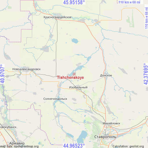
Tishchenskoye GPS coordinates[2]
45° 27' 38.016" North, 41° 40' 25.752" East
| Map corner | latitude | longitude |
|---|---|---|
| Upper-left | 45.95158°, | 40.9707° |
| Center: | 45.46056°, | 41.67382° |
| Lower-right: | 44.96523°, | 42.37695° |
| Map W x H: | 109.7×109.7 km | = 68.2×68.2mi |
| max Lat: | 73.50819° ⇑85.3% North |
| Tishchenskoye: | 45.46056° |
| min Lat: | ⇓14.7% South 41.28413° |
| min Long | Tishchenskoye | max Long |
| -179.12198° | 41.67382° | 179.35046° |
| W 39.1%⇐ | ⇒60.9% E |
Elevation
Elevation of Tishchenskoye is 111 m = 364 ft, and this is 91.6 m = 301 ft below average elevation for this country.
| Max E: |
2518 m = 8261 ft | 66% |
| Avg. | 202.6 m = 665 ft | |
| Tishchenskoye | 111 m = 364 ft | |
Min E: |
-28 m = -92 ft | 34% |
See also: Russia elevation on elevation.city.
Geographical zone
Tishchenskoye is located in North temperate zone (between Tropic of Cancer and the Arctic Circle). Distance of this North polar circle is 2346.4 km =1458 mi to North.| Distance of | km | miles | from Tishchenskoye |
|---|---|---|---|
| North Pole | 4952.3 | 3077.2 | to North |
| Arctic Circle | 2346.4 | 1458 | to North |
| Tropic Cancer | 2448.8 | 1521.6 | to South |
| Equator | 5054.7 | 3140.8 | to South |


Nearby cities:
15 places around Tishchenskoye: (largest is in red/bold)
• Bezopasnoye
29.2 km =18.1 mi,  44°
44°
• Dmitriyevskoye
42.1 km =26.2 mi,  24°
24°
• Donskoye
23.4 km =14.5 mi,  91°
91°
• Izobil’nyy
10.3 km =6.4 mi,  164°
164°
• Krasnogvardeyskoye
44.5 km =27.7 mi,  344°
344°
• Ladovskaya Balka
28.3 km =17.6 mi,  311°
311°
• Mikhaylovsk
46.1 km =28.6 mi,  143°
143°
• Moskovskoye
26.9 km =16.7 mi, 136°
• Novoaleksandrovsk
35.5 km =22.1 mi,  276°
276°
• Novotroitskaya
18.9 km =11.7 mi,  217°
217°
• Pelagiada
39.3 km =24.4 mi, 135°
• Pregradnoye
40.6 km =25.2 mi,  8°
8°
• Ryzdvyanyy
25.2 km =15.7 mi,  149°
149°
• Temizhbekskaya
49.6 km =30.8 mi,  268°
268°
• Trunovskoye
36.1 km =22.4 mi, 85°
Sources, notices
• [Note1] Compared only with cities in Russia existing in our database
• [Src1] Map data: © OpenStreetMap contributors (CC-BY-SA)
• [Src2] Other city data from geonames.org with taken over terms of usage.
• [Src3] Geographical zone / Annual Mean Temperature by Robert A. Rohde @ Wikipedia
