Rossosh’ geodata
Rossosh’ (Voronezj) is a populated place; located in Russia in Europe/Moscow (GMT+3) time zone. With population of 64,323 people, there are 318 cities with bigger population in this country. Compared to other cities in Russia, 74.4% of cities are located further ↑North; 74.4% of cities are located further →East and 68.2% of cities have higher elevation than Rossosh’. Note1


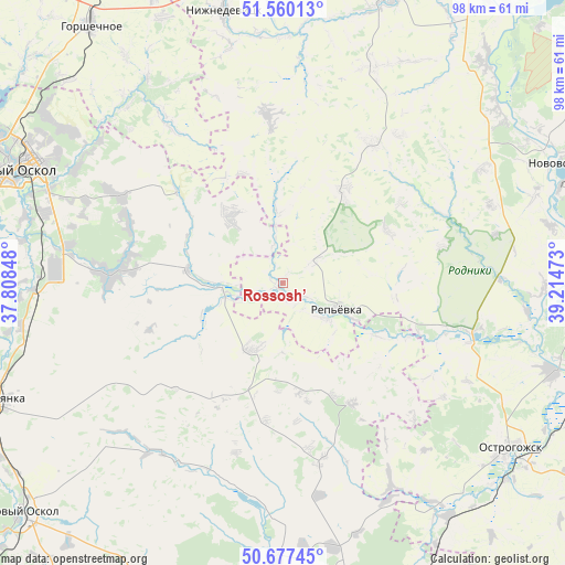
Rossosh’ GPS coordinates[2]
51° 7' 15.24" North, 38° 30' 41.76" East
| Map corner | latitude | longitude |
|---|---|---|
| Upper-left | 51.56013°, | 37.80848° |
| Center: | 51.1209°, | 38.5116° |
| Lower-right: | 50.67745°, | 39.21473° |
| Map W x H: | 98.1×98.1 km | = 61×61mi |
| max Lat: | 73.50819° ⇑74.4% North |
| Rossosh’: | 51.1209° |
| min Lat: | ⇓25.6% South 41.28413° |
| min Long | Rossosh’ | max Long |
| -179.12198° | 38.5116° | 179.35046° |
| W 25.6%⇐ | ⇒74.4% E |
Elevation
Elevation of Rossosh’ is 107 m = 351 ft, and this is 95.6 m = 314 ft below average elevation for this country.
| Max E: |
2518 m = 8261 ft | 68.2% |
| Avg. | 202.6 m = 665 ft | |
| Rossosh’ | 107 m = 351 ft | |
Min E: |
-28 m = -92 ft | 31.8% |
See also: Rossosh’ elevation on elevation.city.
Geographical zone
Rossosh’ is located in North temperate zone (between Tropic of Cancer and the Arctic Circle). Distance of this North polar circle is 1717.1 km =1067 mi to North.| Distance of | km | miles | from Rossosh’ |
|---|---|---|---|
| North Pole | 4323 | 2686.2 | to North |
| Arctic Circle | 1717.1 | 1067 | to North |
| Tropic Cancer | 3078.2 | 1912.7 | to South |
| Equator | 5684.1 | 3531.9 | to South |


Nearby cities:
15 places around Rossosh’: (largest is in red/bold)
• Chernyanka
53.2 km =33.1 mi,  247°
247°
• Gorshechnoye
55.7 km =34.6 mi,  323°
323°
• Ilovka
47 km =29.2 mi,  169°
169°
• Kolodeznyy
52.4 km =32.6 mi,  63°
63°
• Korotoyak
48.8 km =30.3 mi,  107°
107°
• Kostenki
47.4 km =29.5 mi,  50°
50°
• Krasnogvardeyskoye
53 km =32.9 mi,  188°
188°
• Krasnoye
24.4 km =15.2 mi,  150°
150°
• Nizhnedevitsk
47.9 km =29.8 mi,  347°
347°
• Novovoronezh
53.3 km =33.1 mi,  67°
67°
• Ostrogozhsk
48.6 km =30.2 mi,  125°
125°
• Rogovatoye
15.1 km =9.4 mi, 323°
• Staryy Oskol
50.6 km =31.4 mi,  292°
292°
• Uryv-Pokrovka
45.5 km =28.3 mi,  90°
90°
• Zasosna
55.1 km =34.2 mi, 188°
Sources, notices
• [Note1] Compared only with cities in Russia existing in our database
• [Src1] Map data: © OpenStreetMap contributors (CC-BY-SA)
• [Src2] Other city data from geonames.org with taken over terms of usage.
• [Src3] Geographical zone / Annual Mean Temperature by Robert A. Rohde @ Wikipedia
