Roslavl’ geodata
Roslavl’ (Smolensk) is a populated place; located in Russia in Europe/Moscow (GMT+3) time zone. With population of 56,971 people, there are 370 cities with bigger population in this country. Compared to other cities in Russia, 55.7% of cities are located further ↑North; 92.2% of cities are located further →East and 69.8% of cities have lower elevation than Roslavl’. Note1


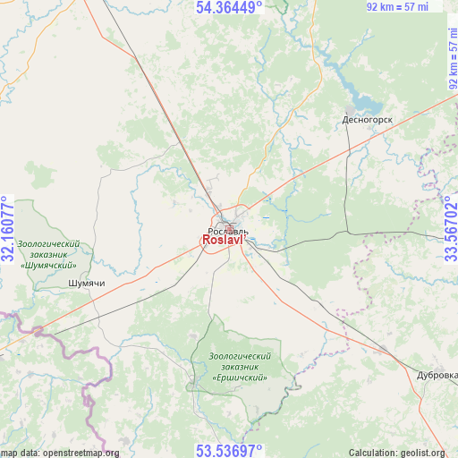
Roslavl’ GPS coordinates[2]
53° 57' 10.008" North, 32° 51' 50.004" East
| Map corner | latitude | longitude |
|---|---|---|
| Upper-left | 54.36449°, | 32.16077° |
| Center: | 53.95278°, | 32.86389° |
| Lower-right: | 53.53697°, | 33.56702° |
| Map W x H: | 92×92 km | = 57.2×57.2mi |
| max Lat: | 73.50819° ⇑55.7% North |
| Roslavl’: | 53.95278° |
| min Lat: | ⇓44.3% South 41.28413° |
| min Long | Roslavl’ | max Long |
| -179.12198° | 32.86389° | 179.35046° |
| W 7.8%⇐ | ⇒92.2% E |
Elevation
Elevation of Roslavl’ is 197 m = 646 ft, and this is 5.6 m = 18 ft below average elevation for this country.
| Max E: |
2518 m = 8261 ft | 30.2% |
| Avg. | 202.6 m = 665 ft | |
| Roslavl’ | 197 m = 646 ft | |
Min E: |
-28 m = -92 ft | 69.8% |
See also: Roslavl’ elevation on elevation.city.
Geographical zone
Roslavl’ is located in North temperate zone (between Tropic of Cancer and the Arctic Circle). Distance of this North polar circle is 1402.2 km =871.3 mi to North.| Distance of | km | miles | from Roslavl’ |
|---|---|---|---|
| North Pole | 4008.1 | 2490.5 | to North |
| Arctic Circle | 1402.2 | 871.3 | to North |
| Tropic Cancer | 3393.1 | 2108.4 | to South |
| Equator | 5999 | 3727.6 | to South |


Nearby cities:
15 places around Roslavl’: (largest is in red/bold)
• Betlitsa
71.9 km =44.7 mi,  84°
84°
• Desnogorsk
35 km =21.7 mi,  51°
51°
• Dubrovka
51.3 km =31.9 mi,  124°
124°
• Khislavichi
52.9 km =32.9 mi,  299°
299°
• Kletnya
66.8 km =41.5 mi,  159°
159°
• Oster
8.2 km =5.1 mi,  330°
330°
• Pochinok
57.5 km =35.7 mi, 331°
• Rognedino
48.5 km =30.1 mi,  110°
110°
• Seshcha
39.4 km =24.5 mi,  127°
127°
• Shatalovo
50.4 km =31.3 mi, 327°
• Shumyachi
30.7 km =19.1 mi,  249°
249°
• Stodolishche
29.5 km =18.3 mi, 331°
• Yekimovichi
33.4 km =20.8 mi,  57°
57°
• Yel’nya
72.6 km =45.1 mi,  16°
16°
• Yershichi
32 km =19.9 mi,  193°
193°
Sources, notices
• [Note1] Compared only with cities in Russia existing in our database
• [Src1] Map data: © OpenStreetMap contributors (CC-BY-SA)
• [Src2] Other city data from geonames.org with taken over terms of usage.
• [Src3] Geographical zone / Annual Mean Temperature by Robert A. Rohde @ Wikipedia
