Shatalovo geodata
Shatalovo (Smolensk) is a populated place; located in Russia in Europe/Moscow (GMT+3) time zone. With population of 4,142 people, there are 3037 cities with bigger population in this country. Compared to other cities in Russia, 52.6% of cities are located further ↑North; 92.7% of cities are located further →East and 68% of cities have lower elevation than Shatalovo. Note1


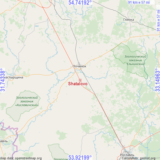
Shatalovo GPS coordinates[2]
54° 20' 2.4" North, 32° 26' 47.4" East
| Map corner | latitude | longitude |
|---|---|---|
| Upper-left | 54.74192°, | 31.74338° |
| Center: | 54.334°, | 32.4465° |
| Lower-right: | 53.92199°, | 33.14963° |
| Map W x H: | 91.2×91.2 km | = 56.7×56.7mi |
| max Lat: | 73.50819° ⇑52.6% North |
| Shatalovo: | 54.334° |
| min Lat: | ⇓47.4% South 41.28413° |
| min Long | Shatalovo | max Long |
| -179.12198° | 32.4465° | 179.35046° |
| W 7.3%⇐ | ⇒92.7% E |
Elevation
Elevation of Shatalovo is 191 m = 627 ft, and this is 11.6 m = 38 ft below average elevation for this country.
| Max E: |
2518 m = 8261 ft | 32% |
| Avg. | 202.6 m = 665 ft | |
| Shatalovo | 191 m = 627 ft | |
Min E: |
-28 m = -92 ft | 68% |
See also: Russia elevation on elevation.city.
Geographical zone
Shatalovo is located in North temperate zone (between Tropic of Cancer and the Arctic Circle). Distance of this North polar circle is 1359.8 km =844.9 mi to North.| Distance of | km | miles | from Shatalovo |
|---|---|---|---|
| North Pole | 3965.7 | 2464.2 | to North |
| Arctic Circle | 1359.8 | 844.9 | to North |
| Tropic Cancer | 3435.5 | 2134.7 | to South |
| Equator | 6041.4 | 3754 | to South |


Nearby cities:
15 places around Shatalovo: (largest is in red/bold)
• Desnogorsk
58 km =36 mi,  110°
110°
• Glinka
44 km =27.3 mi,  39°
39°
• Kardymovo
61.8 km =38.4 mi,  359°
359°
• Khislavichi
24.8 km =15.4 mi,  228°
228°
• Monastyrshchina
39.5 km =24.5 mi,  272°
272°
• Oster
42.2 km =26.2 mi,  146°
146°
• Pechersk
63.7 km =39.6 mi,  335°
335°
• Pochinok
8.1 km =5 mi, 357°
• Roslavl’
50.4 km =31.3 mi, 147°
• Shumyachi
52.9 km =32.9 mi,  181°
181°
• Smolensk
56.3 km =35 mi,  332°
332°
• Stodolishche
21.1 km =13.1 mi,  141°
141°
• Talashkino
39.5 km =24.5 mi, 334°
• Yekimovichi
60.5 km =37.6 mi, 113°
• Yel’nya
54.9 km =34.1 mi,  60°
60°
Sources, notices
• [Note1] Compared only with cities in Russia existing in our database
• [Src1] Map data: © OpenStreetMap contributors (CC-BY-SA)
• [Src2] Other city data from geonames.org with taken over terms of usage.
• [Src3] Geographical zone / Annual Mean Temperature by Robert A. Rohde @ Wikipedia
