Desnogorsk geodata
Desnogorsk (Smolensk) is a populated place; located in Russia in Europe/Moscow (GMT+3) time zone. With population of 32,451 people, there are 615 cities with bigger population in this country. Compared to other cities in Russia, 53.9% of cities are located further ↑North; 91.6% of cities are located further →East and 73% of cities have lower elevation than Desnogorsk. Note1


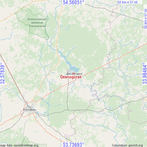
Desnogorsk GPS coordinates[2]
54° 9' 2.772" North, 33° 16' 53.436" East
| Map corner | latitude | longitude |
|---|---|---|
| Upper-left | 54.56051°, | 32.57839° |
| Center: | 54.15077°, | 33.28151° |
| Lower-right: | 53.73693°, | 33.98464° |
| Map W x H: | 91.6×91.6 km | = 56.9×56.9mi |
| max Lat: | 73.50819° ⇑53.9% North |
| Desnogorsk: | 54.15077° |
| min Lat: | ⇓46.1% South 41.28413° |
| min Long | Desnogorsk | max Long |
| -179.12198° | 33.28151° | 179.35046° |
| W 8.4%⇐ | ⇒91.6% E |
Elevation
Elevation of Desnogorsk is 208 m = 682 ft, and this is 5.4 m = 18 ft above average elevation for this country.
| Max E: |
2518 m = 8261 ft | 27% |
| Desnogorsk | 208 m 682 ft | |
| Avg. | 202.6 m = 665 ft | |
Min E: |
-28 m = -92 ft | 73% |
See also: Russia elevation on elevation.city.
Geographical zone
Desnogorsk is located in North temperate zone (between Tropic of Cancer and the Arctic Circle). Distance of this North polar circle is 1380.2 km =857.6 mi to North.| Distance of | km | miles | from Desnogorsk |
|---|---|---|---|
| North Pole | 3986.1 | 2476.8 | to North |
| Arctic Circle | 1380.2 | 857.6 | to North |
| Tropic Cancer | 3415.1 | 2122 | to South |
| Equator | 6021 | 3741.3 | to South |


Nearby cities:
15 places around Desnogorsk: (largest is in red/bold)
• Betlitsa
46.9 km =29.1 mi,  109°
109°
• Bytosh’
64.5 km =40.1 mi,  124°
124°
• Dubrovka
53.2 km =33.1 mi,  163°
163°
• Glinka
60.4 km =37.5 mi,  334°
334°
• Oster
34.6 km =21.5 mi,  244°
244°
• Pochinok
61.6 km =38.3 mi,  297°
297°
• Rognedino
42.8 km =26.6 mi, 155°
• Roslavl’
35 km =21.7 mi,  231°
231°
• Seshcha
46.3 km =28.8 mi,  175°
175°
• Shatalovo
58 km =36 mi,  290°
290°
• Spas-Demensk
56.2 km =34.9 mi,  58°
58°
• Stodolishche
41.3 km =25.7 mi,  275°
275°
• Yekimovichi
4.3 km =2.7 mi,  166°
166°
• Yel’nya
48 km =29.8 mi,  352°
352°
• Yershichi
63.4 km =39.4 mi,  213°
213°
Sources, notices
• [Note1] Compared only with cities in Russia existing in our database
• [Src1] Map data: © OpenStreetMap contributors (CC-BY-SA)
• [Src2] Other city data from geonames.org with taken over terms of usage.
• [Src3] Geographical zone / Annual Mean Temperature by Robert A. Rohde @ Wikipedia
