Dubrovka geodata
Dubrovka (Bryansk Oblast) is a populated place; located in Russia in Europe/Moscow (GMT+3) time zone. With population of 8,427 people, there are 1729 cities with bigger population in this country. Compared to other cities in Russia, 57.5% of cities are located further ↑North; 91.2% of cities are located further →East and 69.5% of cities have lower elevation than Dubrovka. Note1


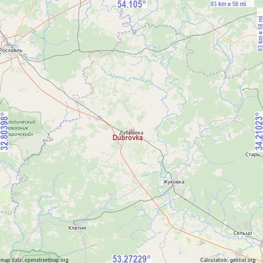
Dubrovka GPS coordinates[2]
53° 41' 26.52" North, 33° 30' 25.56" East
| Map corner | latitude | longitude |
|---|---|---|
| Upper-left | 54.105°, | 32.80398° |
| Center: | 53.6907°, | 33.5071° |
| Lower-right: | 53.27229°, | 34.21023° |
| Map W x H: | 92.6×92.6 km | = 57.5×57.5mi |
| max Lat: | 73.50819° ⇑57.5% North |
| Dubrovka: | 53.6907° |
| min Lat: | ⇓42.5% South 41.28413° |
| min Long | Dubrovka | max Long |
| -179.12198° | 33.5071° | 179.35046° |
| W 8.8%⇐ | ⇒91.2% E |
Elevation
Elevation of Dubrovka is 196 m = 643 ft, and this is 6.6 m = 22 ft below average elevation for this country.
| Max E: |
2518 m = 8261 ft | 30.5% |
| Avg. | 202.6 m = 665 ft | |
| Dubrovka | 196 m = 643 ft | |
Min E: |
-28 m = -92 ft | 69.5% |
See also: Russia elevation on elevation.city.
Geographical zone
Dubrovka is located in North temperate zone (between Tropic of Cancer and the Arctic Circle). Distance of this North polar circle is 1431.3 km =889.4 mi to North.| Distance of | km | miles | from Dubrovka |
|---|---|---|---|
| North Pole | 4037.2 | 2508.6 | to North |
| Arctic Circle | 1431.3 | 889.4 | to North |
| Tropic Cancer | 3363.9 | 2090.2 | to South |
| Equator | 5969.8 | 3709.5 | to South |


Nearby cities:
15 places around Dubrovka: (largest is in red/bold)
• Betlitsa
46.2 km =28.7 mi,  39°
39°
• Bytosh’
40.9 km =25.4 mi,  69°
69°
• Desnogorsk
53.2 km =33.1 mi,  343°
343°
• Ivot
44.8 km =27.8 mi,  92°
92°
• Kletnya
38.6 km =24 mi,  209°
209°
• Ovstug
43.4 km =27 mi,  145°
145°
• Rognedino
12.8 km =8 mi,  15°
15°
• Roslavl’
51.3 km =31.9 mi,  304°
304°
• Rzhanitsa
40.1 km =24.9 mi,  136°
136°
• Sel’tso
53.3 km =33.1 mi,  132°
132°
• Seshcha
12.2 km =7.6 mi,  294°
294°
• Star’
43.1 km =26.8 mi,  99°
99°
• Yekimovichi
48.9 km =30.4 mi, 343°
• Yershichi
49.6 km =30.8 mi,  267°
267°
• Zhukovka
22.7 km =14.1 mi, 140°
Sources, notices
• [Note1] Compared only with cities in Russia existing in our database
• [Src1] Map data: © OpenStreetMap contributors (CC-BY-SA)
• [Src2] Other city data from geonames.org with taken over terms of usage.
• [Src3] Geographical zone / Annual Mean Temperature by Robert A. Rohde @ Wikipedia
