Pshada geodata
Pshada (Krasnodarskiy) is a populated place; located in Russia in Europe/Moscow (GMT+3) time zone. With population of 2,875 people, there are 3839 cities with bigger population in this country. Compared to other cities in Russia, 89.5% of cities are located further ↑North; 74.8% of cities are located further →East and 86.3% of cities have higher elevation than Pshada. Note1


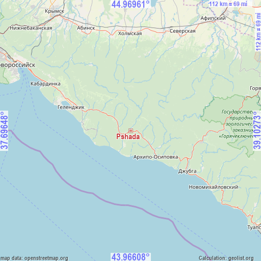
Pshada GPS coordinates[2]
44° 28' 12" North, 38° 23' 58.56" East
| Map corner | latitude | longitude |
|---|---|---|
| Upper-left | 44.96961°, | 37.69648° |
| Center: | 44.47°, | 38.3996° |
| Lower-right: | 43.96608°, | 39.10273° |
| Map W x H: | 111.6×111.6 km | = 69.3×69.3mi |
| max Lat: | 73.50819° ⇑89.5% North |
| Pshada: | 44.47° |
| min Lat: | ⇓10.5% South 41.28413° |
| min Long | Pshada | max Long |
| -179.12198° | 38.3996° | 179.35046° |
| W 25.2%⇐ | ⇒74.8% E |
Elevation
Elevation of Pshada is 42 m = 138 ft, and this is 160.6 m = 527 ft below average elevation for this country.
| Max E: |
2518 m = 8261 ft | 86.3% |
| Avg. | 202.6 m = 665 ft | |
| Pshada | 42 m = 138 ft | |
Min E: |
-28 m = -92 ft | 13.7% |
See also: Russia elevation on elevation.city.
Geographical zone
Pshada is located in North temperate zone (between Tropic of Cancer and the Arctic Circle). Distance of this Northern Tropic circle is 2338.7 km =1453.2 mi to South.| Distance of | km | miles | from Pshada |
|---|---|---|---|
| North Pole | 5062.5 | 3145.7 | to North |
| Arctic Circle | 2456.6 | 1526.5 | to North |
| Tropic Cancer | 2338.7 | 1453.2 | to South |
| Equator | 4944.6 | 3072.4 | to South |


Nearby cities:
15 places around Pshada: (largest is in red/bold)
• Akhtyrskiy
43.4 km =27 mi,  349°
349°
• Arkhipo-Osipovka
15 km =9.3 mi,  136°
136°
• Azovskaya
39.9 km =24.8 mi,  26°
26°
• Betta
10.7 km =6.6 mi,  182°
182°
• Chernomorskiy
43 km =26.7 mi,  9°
9°
• Divnomorskoye
21.3 km =13.2 mi,  279°
279°
• Dzhubga
29.5 km =18.3 mi,  124°
124°
• Gelendzhik
27 km =16.8 mi,  292°
292°
• Il’skiy
43.4 km =27 mi,  17°
17°
• Kabardinka
41.4 km =25.7 mi,  299°
299°
• Kholmskiy
41.9 km =26 mi,  358°
358°
• Lermontovo
33.9 km =21.1 mi, 123°
• Novomikhaylovskiy
43.2 km =26.8 mi, 122°
• Severskaya
48 km =29.8 mi, 27°
• Smolenskaya
47.5 km =29.5 mi,  42°
42°
Sources, notices
• [Note1] Compared only with cities in Russia existing in our database
• [Src1] Map data: © OpenStreetMap contributors (CC-BY-SA)
• [Src2] Other city data from geonames.org with taken over terms of usage.
• [Src3] Geographical zone / Annual Mean Temperature by Robert A. Rohde @ Wikipedia
