Arkhipo-Osipovka geodata
Arkhipo-Osipovka (Krasnodarskiy) is a populated place; located in Russia in Europe/Moscow (GMT+3) time zone. With population of 8,170 people, there are 1772 cities with bigger population in this country. Compared to other cities in Russia, 89.9% of cities are located further ↑North; 74.3% of cities are located further →East and 97.6% of cities have higher elevation than Arkhipo-Osipovka. Note1


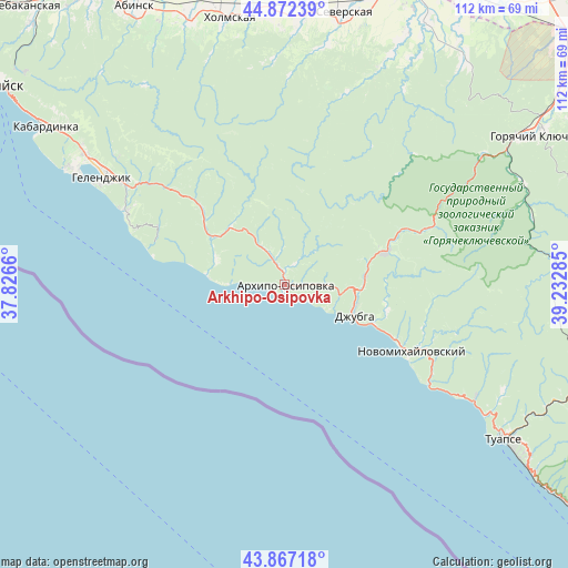
Arkhipo-Osipovka GPS coordinates[2]
44° 22' 18.984" North, 38° 31' 46.992" East
| Map corner | latitude | longitude |
|---|---|---|
| Upper-left | 44.87239°, | 37.8266° |
| Center: | 44.37194°, | 38.52972° |
| Lower-right: | 43.86718°, | 39.23285° |
| Map W x H: | 111.8×111.8 km | = 69.5×69.5mi |
| max Lat: | 73.50819° ⇑89.9% North |
| Arkhipo-Osipovka: | 44.37194° |
| min Lat: | ⇓10.1% South 41.28413° |
| min Long | Arkhipo-Osipovk | max Long |
| -179.12198° | 38.52972° | 179.35046° |
| W 25.7%⇐ | ⇒74.3% E |
Elevation
Elevation of Arkhipo-Osipovka is 6 m = 20 ft, and this is 196.6 m = 645 ft below average elevation for this country.
| Max E: |
2518 m = 8261 ft | 97.6% |
| Avg. | 202.6 m = 665 ft | |
| Arkhipo-Osipovka | 6 m = 20 ft | |
Min E: |
-28 m = -92 ft | 2.4% |
See also: Russia elevation on elevation.city.
Geographical zone
Arkhipo-Osipovka is located in North temperate zone (between Tropic of Cancer and the Arctic Circle). Distance of this Northern Tropic circle is 2327.8 km =1446.4 mi to South.| Distance of | km | miles | from Arkhipo-Osipovka |
|---|---|---|---|
| North Pole | 5073.4 | 3152.5 | to North |
| Arctic Circle | 2467.5 | 1533.2 | to North |
| Tropic Cancer | 2327.8 | 1446.4 | to South |
| Equator | 4933.7 | 3065.7 | to South |


Nearby cities:
15 places around Arkhipo-Osipovka: (largest is in red/bold)
• Agoy
47.6 km =29.6 mi,  121°
121°
• Azovskaya
47.2 km =29.3 mi,  9°
9°
• Betta
10.8 km =6.7 mi,  270°
270°
• Chernomorskiy
53.3 km =33.1 mi,  356°
356°
• Divnomorskoye
34.6 km =21.5 mi,  294°
294°
• Dzhubga
15.2 km =9.4 mi,  111°
111°
• Gelendzhik
41.2 km =25.6 mi,  300°
300°
• Il’skiy
52.4 km =32.6 mi,  3°
3°
• Lermontovo
19.6 km =12.2 mi, 112°
• Nebug
43.7 km =27.2 mi, 120°
• Novomikhaylovskiy
28.8 km =17.9 mi, 114°
• Ol’ginka
34.1 km =21.2 mi, 122°
• Pshada
15 km =9.3 mi,  316°
316°
• Smolenskaya
50.9 km =31.6 mi,  25°
25°
• Tuapse
52.9 km =32.9 mi, 124°
Sources, notices
• [Note1] Compared only with cities in Russia existing in our database
• [Src1] Map data: © OpenStreetMap contributors (CC-BY-SA)
• [Src2] Other city data from geonames.org with taken over terms of usage.
• [Src3] Geographical zone / Annual Mean Temperature by Robert A. Rohde @ Wikipedia
