Plekhanovo geodata
Plekhanovo (Lipetsk Oblast) is a populated place; located in Russia in Europe/Moscow (GMT+3) time zone. With population of 1,850 people, there are 4235 cities with bigger population in this country. Compared to other cities in Russia, 65.2% of cities are located further ↑North; 68.3% of cities are located further →East and 58.2% of cities have higher elevation than Plekhanovo. Note1


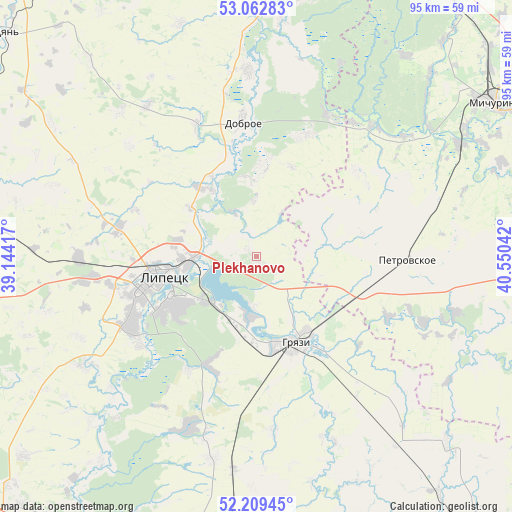
Plekhanovo GPS coordinates[2]
52° 38' 17.592" North, 39° 50' 50.244" East
| Map corner | latitude | longitude |
|---|---|---|
| Upper-left | 53.06283°, | 39.14417° |
| Center: | 52.63822°, | 39.84729° |
| Lower-right: | 52.20945°, | 40.55042° |
| Map W x H: | 94.9×94.9 km | = 59×59mi |
| max Lat: | 73.50819° ⇑65.2% North |
| Plekhanovo: | 52.63822° |
| min Lat: | ⇓34.8% South 41.28413° |
| min Long | Plekhanovo | max Long |
| -179.12198° | 39.84729° | 179.35046° |
| W 31.7%⇐ | ⇒68.3% E |
Elevation
Elevation of Plekhanovo is 128 m = 420 ft, and this is 74.6 m = 245 ft below average elevation for this country.
| Max E: |
2518 m = 8261 ft | 58.2% |
| Avg. | 202.6 m = 665 ft | |
| Plekhanovo | 128 m = 420 ft | |
Min E: |
-28 m = -92 ft | 41.8% |
See also: Russia elevation on elevation.city.
Geographical zone
Plekhanovo is located in North temperate zone (between Tropic of Cancer and the Arctic Circle). Distance of this North polar circle is 1548.4 km =962.1 mi to North.| Distance of | km | miles | from Plekhanovo |
|---|---|---|---|
| North Pole | 4154.2 | 2581.3 | to North |
| Arctic Circle | 1548.4 | 962.1 | to North |
| Tropic Cancer | 3246.9 | 2017.5 | to South |
| Equator | 5852.8 | 3636.8 | to South |


Nearby cities:
15 places around Plekhanovo: (largest is in red/bold)
• Bol’shoy Khomutets
16.2 km =10.1 mi,  5°
5°
• Borinskoye
38 km =23.6 mi,  237°
237°
• Dobroye
25.6 km =15.9 mi,  354°
354°
• Donskoye
59 km =36.7 mi,  267°
267°
• Gryazi
16.9 km =10.5 mi,  159°
159°
• Kalikino
34.6 km =21.5 mi,  357°
357°
• Kazinka
11.3 km =7 mi,  188°
188°
• Kuz’minskiye Otverzhki
26.2 km =16.3 mi,  284°
284°
• Lebedyan’
62.4 km =38.8 mi,  312°
312°
• Lipetsk
19.1 km =11.9 mi,  258°
258°
• Michurinsk
52 km =32.3 mi,  56°
56°
• Prigorodka
66.6 km =41.4 mi, 187°
• Syrskoye
24.7 km =15.3 mi,  253°
253°
• Usman’
66.3 km =41.2 mi, 186°
• Zavoronezhskoye
54.5 km =33.9 mi, 60°
Sources, notices
• [Note1] Compared only with cities in Russia existing in our database
• [Src1] Map data: © OpenStreetMap contributors (CC-BY-SA)
• [Src2] Other city data from geonames.org with taken over terms of usage.
• [Src3] Geographical zone / Annual Mean Temperature by Robert A. Rohde @ Wikipedia
