Petropavlovskaya geodata
Petropavlovskaya (Krasnodarskiy) is a populated place; located in Russia in Europe/Moscow (GMT+3) time zone. With population of 6,632 people, there are 2092 cities with bigger population in this country. Compared to other cities in Russia, 86.9% of cities are located further ↑North; 65.3% of cities are located further →East and 63.5% of cities have higher elevation than Petropavlovskaya. Note1


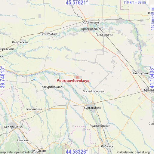
Petropavlovskaya GPS coordinates[2]
45° 4' 54.804" North, 40° 27' 4.5" East
| Map corner | latitude | longitude |
|---|---|---|
| Upper-left | 45.57621°, | 39.74813° |
| Center: | 45.08189°, | 40.45125° |
| Lower-right: | 44.58326°, | 41.15438° |
| Map W x H: | 110.4×110.4 km | = 68.6×68.6mi |
| max Lat: | 73.50819° ⇑86.9% North |
| Petropavlovskaya: | 45.08189° |
| min Lat: | ⇓13.1% South 41.28413° |
| min Long | Petropavlovskay | max Long |
| -179.12198° | 40.45125° | 179.35046° |
| W 34.7%⇐ | ⇒65.3% E |
Elevation
Elevation of Petropavlovskaya is 117 m = 384 ft, and this is 85.6 m = 281 ft below average elevation for this country.
| Max E: |
2518 m = 8261 ft | 63.5% |
| Avg. | 202.6 m = 665 ft | |
| Petropavlovskaya | 117 m = 384 ft | |
Min E: |
-28 m = -92 ft | 36.5% |
See also: Russia elevation on elevation.city.
Geographical zone
Petropavlovskaya is located in North temperate zone (between Tropic of Cancer and the Arctic Circle). Distance of this North polar circle is 2388.5 km =1484.1 mi to North.| Distance of | km | miles | from Petropavlovskaya |
|---|---|---|---|
| North Pole | 4994.4 | 3103.4 | to North |
| Arctic Circle | 2388.5 | 1484.1 | to North |
| Tropic Cancer | 2406.7 | 1495.5 | to South |
| Equator | 5012.6 | 3114.7 | to South |


Nearby cities:
15 places around Petropavlovskaya: (largest is in red/bold)
• Blechepsin
29.3 km =18.2 mi,  172°
172°
• Dondukovskaya
23.3 km =14.5 mi,  197°
197°
• Gul’kevichi
35.7 km =22.2 mi,  32°
32°
• Kazanskaya
36.6 km =22.7 mi,  358°
358°
• Konstantinovskaya
35 km =21.7 mi,  141°
141°
• Koshekhabl’
21.1 km =13.1 mi, 166°
• Kurganinsk
25.3 km =15.7 mi,  152°
152°
• Mikhaylovskaya
15 km =9.3 mi,  130°
130°
• Novoukrainskoye
33.5 km =20.8 mi,  10°
10°
• Otrado-Kubanskoye
35.5 km =22.1 mi,  59°
59°
• Shovgenovskiy
19.5 km =12.1 mi,  245°
245°
• Sokolovskoye
26.6 km =16.5 mi,  42°
42°
• Tbilisskaya
37.4 km =23.2 mi,  326°
326°
• Temirgoyevskaya
13.9 km =8.6 mi,  284°
284°
• Yuzhnyy
9 km =5.6 mi, 168°
Sources, notices
• [Note1] Compared only with cities in Russia existing in our database
• [Src1] Map data: © OpenStreetMap contributors (CC-BY-SA)
• [Src2] Other city data from geonames.org with taken over terms of usage.
• [Src3] Geographical zone / Annual Mean Temperature by Robert A. Rohde @ Wikipedia
