Temirgoyevskaya geodata
Temirgoyevskaya (Krasnodarskiy) is a populated place; located in Russia in Europe/Moscow (GMT+3) time zone. With population of 8,588 people, there are 1705 cities with bigger population in this country. Compared to other cities in Russia, 86.8% of cities are located further ↑North; 66.1% of cities are located further →East and 73.4% of cities have higher elevation than Temirgoyevskaya. Note1


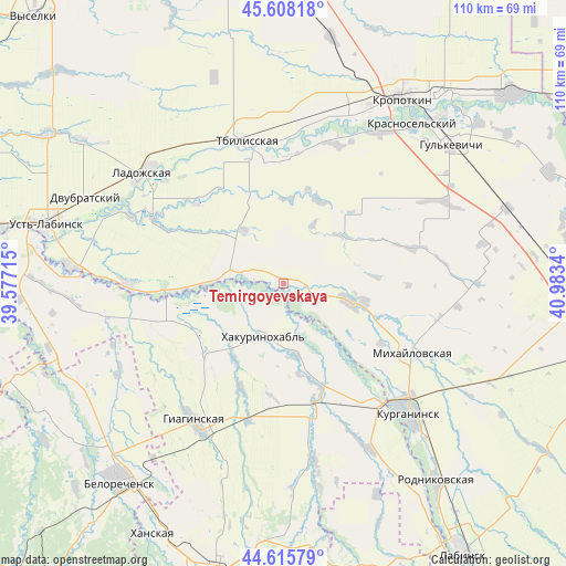
Temirgoyevskaya GPS coordinates[2]
45° 6' 50.904" North, 40° 16' 48.972" East
| Map corner | latitude | longitude |
|---|---|---|
| Upper-left | 45.60818°, | 39.57715° |
| Center: | 45.11414°, | 40.28027° |
| Lower-right: | 44.61579°, | 40.9834° |
| Map W x H: | 110.3×110.3 km | = 68.5×68.5mi |
| max Lat: | 73.50819° ⇑86.8% North |
| Temirgoyevskaya: | 45.11414° |
| min Lat: | ⇓13.2% South 41.28413° |
| min Long | Temirgoyevskaya | max Long |
| -179.12198° | 40.28027° | 179.35046° |
| W 33.9%⇐ | ⇒66.1% E |
Elevation
Elevation of Temirgoyevskaya is 93 m = 305 ft, and this is 109.6 m = 360 ft below average elevation for this country.
| Max E: |
2518 m = 8261 ft | 73.4% |
| Avg. | 202.6 m = 665 ft | |
| Temirgoyevskaya | 93 m = 305 ft | |
Min E: |
-28 m = -92 ft | 26.6% |
See also: Russia elevation on elevation.city.
Geographical zone
Temirgoyevskaya is located in North temperate zone (between Tropic of Cancer and the Arctic Circle). Distance of this North polar circle is 2385 km =1482 mi to North.| Distance of | km | miles | from Temirgoyevskaya |
|---|---|---|---|
| North Pole | 4990.8 | 3101.1 | to North |
| Arctic Circle | 2385 | 1482 | to North |
| Tropic Cancer | 2410.3 | 1497.7 | to South |
| Equator | 5016.2 | 3116.9 | to South |


Nearby cities:
15 places around Temirgoyevskaya: (largest is in red/bold)
• Blechepsin
37 km =23 mi,  152°
152°
• Dondukovskaya
26.6 km =16.5 mi,  165°
165°
• Giaginskaya
32.5 km =20.2 mi,  210°
210°
• Kazanskaya
35.1 km =21.8 mi,  20°
20°
• Koshekhabl’
30.2 km =18.8 mi,  142°
142°
• Kurganinsk
36.1 km =22.4 mi, 136°
• Ladozhskaya
34.5 km =21.4 mi,  308°
308°
• Mikhaylovskaya
28.2 km =17.5 mi,  118°
118°
• Novolabinskaya
30.3 km =18.8 mi,  269°
269°
• Novoukrainskoye
35.3 km =21.9 mi,  33°
33°
• Petropavlovskaya
13.9 km =8.6 mi,  104°
104°
• Shovgenovskiy
12.3 km =7.6 mi,  200°
200°
• Sokolovskoye
35.2 km =21.9 mi,  62°
62°
• Tbilisskaya
28.6 km =17.8 mi,  345°
345°
• Yuzhnyy
19.7 km =12.2 mi,  129°
129°
Sources, notices
• [Note1] Compared only with cities in Russia existing in our database
• [Src1] Map data: © OpenStreetMap contributors (CC-BY-SA)
• [Src2] Other city data from geonames.org with taken over terms of usage.
• [Src3] Geographical zone / Annual Mean Temperature by Robert A. Rohde @ Wikipedia
