Murom geodata
Murom (Vladimir) is a populated place; located in Russia in Europe/Moscow (GMT+3) time zone. With population of 126,931 people, there are 160 cities with bigger population in this country. Compared to other cities in Russia, 59.2% of cities are located further ↓South; 59.5% of cities are located further →East and 63.5% of cities have higher elevation than Murom. Note1


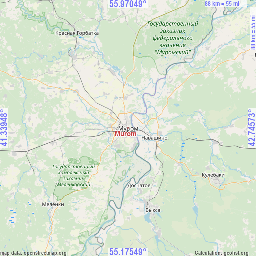
Murom GPS coordinates[2]
55° 34' 30" North, 42° 2' 33.36" East
| Map corner | latitude | longitude |
|---|---|---|
| Upper-left | 55.97049°, | 41.33948° |
| Center: | 55.575°, | 42.0426° |
| Lower-right: | 55.17549°, | 42.74573° |
| Map W x H: | 88.4×88.4 km | = 54.9×54.9mi |
| max Lat: | 73.50819° ⇑40.8% North |
| Murom: | 55.575° |
| min Lat: | ⇓59.2% South 41.28413° |
| min Long | Murom | max Long |
| -179.12198° | 42.0426° | 179.35046° |
| W 40.5%⇐ | ⇒59.5% E |
Elevation
Elevation of Murom is 117 m = 384 ft, and this is 85.6 m = 281 ft below average elevation for this country.
| Max E: |
2518 m = 8261 ft | 63.5% |
| Avg. | 202.6 m = 665 ft | |
| Murom | 117 m = 384 ft | |
Min E: |
-28 m = -92 ft | 36.5% |
See also: Murom elevation on elevation.city.
Geographical zone
Murom is located in North temperate zone (between Tropic of Cancer and the Arctic Circle). Distance of this North polar circle is 1221.8 km =759.2 mi to North.| Distance of | km | miles | from Murom |
|---|---|---|---|
| North Pole | 3827.7 | 2378.4 | to North |
| Arctic Circle | 1221.8 | 759.2 | to North |
| Tropic Cancer | 3573.4 | 2220.4 | to South |
| Equator | 6179.4 | 3839.7 | to South |


Nearby cities:
15 places around Murom: (largest is in red/bold)
• Blizhne-Pesochnoye
25.8 km =16 mi,  171°
171°
• Dobryatino
46.1 km =28.6 mi,  260°
260°
• Doschatoye
21.1 km =13.1 mi, 169°
• Imeni Vorovskogo
60.3 km =37.5 mi,  285°
285°
• Krasnaya Gorbatka
37.2 km =23.1 mi,  332°
332°
• Kulebaki
35.7 km =22.2 mi,  120°
120°
• Melenki
37.3 km =23.2 mi,  224°
224°
• Navashino
10.3 km =6.4 mi,  109°
109°
• Savasleyka
21.6 km =13.4 mi,  126°
126°
• Shimorskoye
27.5 km =17.1 mi,  182°
182°
• Vacha
52.2 km =32.4 mi,  60°
60°
• Velet’ma
35.8 km =22.2 mi,  138°
138°
• Vilya
38.1 km =23.7 mi,  164°
164°
• Vyksa
29.8 km =18.5 mi, 163°
• Zolotkovo
59.2 km =36.8 mi, 264°
Sources, notices
• [Note1] Compared only with cities in Russia existing in our database
• [Src1] Map data: © OpenStreetMap contributors (CC-BY-SA)
• [Src2] Other city data from geonames.org with taken over terms of usage.
• [Src3] Geographical zone / Annual Mean Temperature by Robert A. Rohde @ Wikipedia
