Kulebaki geodata
Kulebaki (Nizhny Novgorod Oblast) is a populated place; located in Russia in Europe/Moscow (GMT+3) time zone. With population of 37,622 people, there are 552 cities with bigger population in this country. Compared to other cities in Russia, 57.3% of cities are located further ↓South; 58.2% of cities are located further →East and 68.2% of cities have higher elevation than Kulebaki. Note1


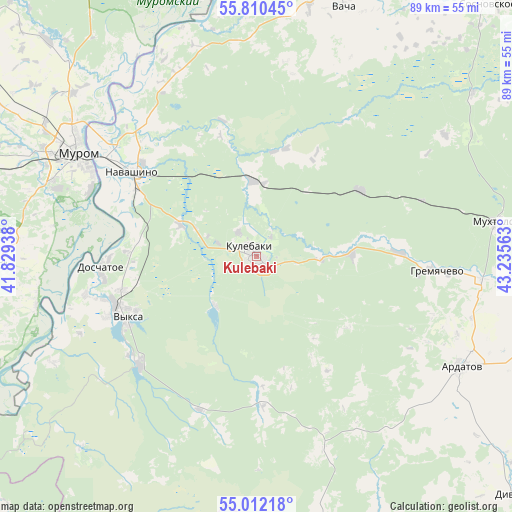
Kulebaki GPS coordinates[2]
55° 24' 47.988" North, 42° 31' 57" East
| Map corner | latitude | longitude |
|---|---|---|
| Upper-left | 55.81045°, | 41.82938° |
| Center: | 55.41333°, | 42.5325° |
| Lower-right: | 55.01218°, | 43.23563° |
| Map W x H: | 88.8×88.8 km | = 55.2×55.2mi |
| max Lat: | 73.50819° ⇑42.7% North |
| Kulebaki: | 55.41333° |
| min Lat: | ⇓57.3% South 41.28413° |
| min Long | Kulebaki | max Long |
| -179.12198° | 42.5325° | 179.35046° |
| W 41.8%⇐ | ⇒58.2% E |
Elevation
Elevation of Kulebaki is 107 m = 351 ft, and this is 95.6 m = 314 ft below average elevation for this country.
| Max E: |
2518 m = 8261 ft | 68.2% |
| Avg. | 202.6 m = 665 ft | |
| Kulebaki | 107 m = 351 ft | |
Min E: |
-28 m = -92 ft | 31.8% |
See also: Russia elevation on elevation.city.
Geographical zone
Kulebaki is located in North temperate zone (between Tropic of Cancer and the Arctic Circle). Distance of this North polar circle is 1239.8 km =770.4 mi to North.| Distance of | km | miles | from Kulebaki |
|---|---|---|---|
| North Pole | 3845.7 | 2389.6 | to North |
| Arctic Circle | 1239.8 | 770.4 | to North |
| Tropic Cancer | 3555.5 | 2209.3 | to South |
| Equator | 6161.4 | 3828.5 | to South |


Nearby cities:
15 places around Kulebaki: (largest is in red/bold)
• Ardatov
40.5 km =25.2 mi,  118°
118°
• Blizhne-Pesochnoye
28.2 km =17.5 mi,  254°
254°
• Doschatoye
27.2 km =16.9 mi,  264°
264°
• Gremyachevo
31.3 km =19.4 mi,  94°
94°
• Melenki
57.7 km =35.9 mi, 261°
• Mukhtolovo
42.5 km =26.4 mi,  81°
81°
• Murom
35.7 km =22.2 mi,  300°
300°
• Navashino
25.7 km =16 mi, 304°
• Savasleyka
14.4 km =8.9 mi,  291°
291°
• Shimorskoye
33.4 km =20.8 mi, 253°
• Sosnovskoye
59.1 km =36.7 mi,  42°
42°
• Vacha
45.9 km =28.5 mi,  19°
19°
• Velet’ma
11.2 km =7 mi,  218°
218°
• Vilya
27.7 km =17.2 mi,  227°
227°
• Vyksa
25 km =15.5 mi,  244°
244°
Sources, notices
• [Note1] Compared only with cities in Russia existing in our database
• [Src1] Map data: © OpenStreetMap contributors (CC-BY-SA)
• [Src2] Other city data from geonames.org with taken over terms of usage.
• [Src3] Geographical zone / Annual Mean Temperature by Robert A. Rohde @ Wikipedia
