Zolotkovo geodata
Zolotkovo (Vladimir) is a populated place; located in Russia in Europe/Moscow (GMT+3) time zone. With population of 3,655 people, there are 3302 cities with bigger population in this country. Compared to other cities in Russia, 58.4% of cities are located further ↓South; 62.7% of cities are located further →East and 58.2% of cities have higher elevation than Zolotkovo. Note1


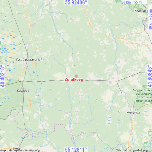
Zolotkovo GPS coordinates[2]
55° 31' 41.16" North, 41° 6' 19.08" East
| Map corner | latitude | longitude |
|---|---|---|
| Upper-left | 55.92406°, | 40.40218° |
| Center: | 55.5281°, | 41.1053° |
| Lower-right: | 55.12811°, | 41.80843° |
| Map W x H: | 88.5×88.5 km | = 55×55mi |
| max Lat: | 73.50819° ⇑41.6% North |
| Zolotkovo: | 55.5281° |
| min Lat: | ⇓58.4% South 41.28413° |
| min Long | Zolotkovo | max Long |
| -179.12198° | 41.1053° | 179.35046° |
| W 37.3%⇐ | ⇒62.7% E |
Elevation
Elevation of Zolotkovo is 128 m = 420 ft, and this is 74.6 m = 245 ft below average elevation for this country.
| Max E: |
2518 m = 8261 ft | 58.2% |
| Avg. | 202.6 m = 665 ft | |
| Zolotkovo | 128 m = 420 ft | |
Min E: |
-28 m = -92 ft | 41.8% |
See also: Russia elevation on elevation.city.
Geographical zone
Zolotkovo is located in North temperate zone (between Tropic of Cancer and the Arctic Circle). Distance of this North polar circle is 1227 km =762.4 mi to North.| Distance of | km | miles | from Zolotkovo |
|---|---|---|---|
| North Pole | 3832.9 | 2381.7 | to North |
| Arctic Circle | 1227 | 762.4 | to North |
| Tropic Cancer | 3568.2 | 2217.2 | to South |
| Equator | 6174.1 | 3836.4 | to South |


Nearby cities:
15 places around Zolotkovo: (largest is in red/bold)
• Andreyevo
46.6 km =29 mi,  3°
3°
• Anopino
33.4 km =20.8 mi,  304°
304°
• Dobryatino
13.7 km =8.5 mi,  100°
100°
• Erleks
46 km =28.6 mi,  280°
280°
• Gusevskiy
37.2 km =23.1 mi,  293°
293°
• Gus’-Khrustal’nyy
30 km =18.6 mi, 287°
• Gus’-Zheleznyy
52.4 km =32.6 mi,  175°
175°
• Imeni Vorovskogo
21.8 km =13.5 mi, 2°
• Ivanishchi
50.6 km =31.4 mi, 302°
• Kurlovo
40.5 km =25.2 mi,  254°
254°
• Melenki
39.5 km =24.5 mi,  123°
123°
• Mezinovskiy
47 km =29.2 mi,  266°
266°
• Muromtsevo
46.5 km =28.9 mi,  344°
344°
• Sudogda
49.7 km =30.9 mi, 342°
• Velikodvorskiy
41.5 km =25.8 mi,  221°
221°
Sources, notices
• [Note1] Compared only with cities in Russia existing in our database
• [Src1] Map data: © OpenStreetMap contributors (CC-BY-SA)
• [Src2] Other city data from geonames.org with taken over terms of usage.
• [Src3] Geographical zone / Annual Mean Temperature by Robert A. Rohde @ Wikipedia
