Mineralnye Vody geodata
Mineralnye Vody (Stavropol’ Kray) is a populated place; located in Russia in Europe/Moscow (GMT+3) time zone. With population of 76,280 people, there are 268 cities with bigger population in this country. Compared to other cities in Russia, 90.7% of cities are located further ↑North; 56.2% of cities are located further →East and 84.4% of cities have lower elevation than Mineralnye Vody. Note1


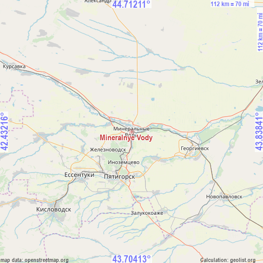
Mineralnye Vody GPS coordinates[2]
44° 12' 37.008" North, 43° 8' 7.008" East
| Map corner | latitude | longitude |
|---|---|---|
| Upper-left | 44.71211°, | 42.43216° |
| Center: | 44.21028°, | 43.13528° |
| Lower-right: | 43.70413°, | 43.83841° |
| Map W x H: | 112.1×112.1 km | = 69.7×69.7mi |
| max Lat: | 73.50819° ⇑90.7% North |
| Mineralnye Vody: | 44.21028° |
| min Lat: | ⇓9.3% South 41.28413° |
| min Long | Mineralnye Vody | max Long |
| -179.12198° | 43.13528° | 179.35046° |
| W 43.8%⇐ | ⇒56.2% E |
Elevation
Elevation of Mineralnye Vody is 310 m = 1017 ft, and this is 107.4 m = 352 ft above average elevation for this country.
| Max E: |
2518 m = 8261 ft | 15.6% |
| Mineralnye Vody | 310 m 1017 ft | |
| Avg. | 202.6 m = 665 ft | |
Min E: |
-28 m = -92 ft | 84.4% |
See also: Mineralnye Vody elevation on elevation.city.
Geographical zone
Mineralnye Vody is located in North temperate zone (between Tropic of Cancer and the Arctic Circle). Distance of this Northern Tropic circle is 2309.8 km =1435.2 mi to South.| Distance of | km | miles | from Mineralnye Vody |
|---|---|---|---|
| North Pole | 5091.3 | 3163.6 | to North |
| Arctic Circle | 2485.5 | 1544.4 | to North |
| Tropic Cancer | 2309.8 | 1435.2 | to South |
| Equator | 4915.7 | 3054.5 | to South |


Nearby cities:
15 places around Mineralnye Vody: (largest is in red/bold)
• Aleksandriyskaya
16.8 km =10.4 mi,  83°
83°
• Andzhiyevskiy
5.1 km =3.2 mi,  308°
308°
• Goryachevodskiy
21 km =13 mi,  189°
189°
• Inozemtsevo
13.5 km =8.4 mi,  195°
195°
• Kangly
9.7 km =6 mi,  300°
300°
• Konstantinovskaya
18.4 km =11.4 mi,  174°
174°
• Lermontov
17.3 km =10.7 mi,  228°
228°
• Levokumka
2.7 km =1.7 mi,  26°
26°
• Lysogorskaya
16.1 km =10 mi,  135°
135°
• Novoterskiy
7.7 km =4.8 mi,  206°
206°
• Podkumskiy
16.1 km =10 mi,  158°
158°
• Pyatigorsk
19 km =11.8 mi, 198°
• Vinsady
19.8 km =12.3 mi,  223°
223°
• Zheleznovodsk
12.1 km =7.5 mi, 229°
• Zmeyka
7.6 km =4.7 mi, 188°
In other languages:
- In German: Mineralnyje Wody
- In Italian: Mineral'nye Vody
- In Russian: Минеральные Воды
- In Chinese: 礦水城
Sources, notices
• [Note1] Compared only with cities in Russia existing in our database
• [Src1] Map data: © OpenStreetMap contributors (CC-BY-SA)
• [Src2] Other city data from geonames.org with taken over terms of usage.
• [Src3] Geographical zone / Annual Mean Temperature by Robert A. Rohde @ Wikipedia
