Lysogorskaya geodata
Lysogorskaya (Stavropol’ Kray) is a populated place; located in Russia in Europe/Moscow (GMT+3) time zone. With population of 10,219 people, there are 1476 cities with bigger population in this country. Compared to other cities in Russia, 91.3% of cities are located further ↑North; 55.5% of cities are located further →East and 86.5% of cities have lower elevation than Lysogorskaya. Note1


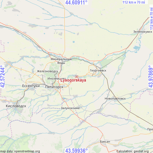
Lysogorskaya GPS coordinates[2]
44° 6' 23.004" North, 43° 16' 32.016" East
| Map corner | latitude | longitude |
|---|---|---|
| Upper-left | 44.60911°, | 42.57244° |
| Center: | 44.10639°, | 43.27556° |
| Lower-right: | 43.59936°, | 43.97869° |
| Map W x H: | 112.3×112.3 km | = 69.8×69.8mi |
| max Lat: | 73.50819° ⇑91.3% North |
| Lysogorskaya: | 44.10639° |
| min Lat: | ⇓8.7% South 41.28413° |
| min Long | Lysogorskaya | max Long |
| -179.12198° | 43.27556° | 179.35046° |
| W 44.5%⇐ | ⇒55.5% E |
Elevation
Elevation of Lysogorskaya is 355 m = 1165 ft, and this is 152.4 m = 500 ft above average elevation for this country.
| Max E: |
2518 m = 8261 ft | 13.5% |
| Lysogorskaya | 355 m 1165 ft | |
| Avg. | 202.6 m = 665 ft | |
Min E: |
-28 m = -92 ft | 86.5% |
See also: Russia elevation on elevation.city.
Geographical zone
Lysogorskaya is located in North temperate zone (between Tropic of Cancer and the Arctic Circle). Distance of this Northern Tropic circle is 2298.3 km =1428.1 mi to South.| Distance of | km | miles | from Lysogorskaya |
|---|---|---|---|
| North Pole | 5102.9 | 3170.8 | to North |
| Arctic Circle | 2497 | 1551.6 | to North |
| Tropic Cancer | 2298.3 | 1428.1 | to South |
| Equator | 4904.2 | 3047.3 | to South |


Nearby cities:
15 places around Lysogorskaya: (largest is in red/bold)
• Aleksandriyskaya
14.5 km =9 mi,  22°
22°
• Georgiyevsk
16.3 km =10.1 mi,  71°
71°
• Georgiyevskaya
17.3 km =10.7 mi,  88°
88°
• Goryachevodskiy
17.3 km =10.7 mi,  237°
237°
• Inozemtsevo
14.8 km =9.2 mi,  264°
264°
• Konstantinovskaya
11.6 km =7.2 mi,  234°
234°
• Levokumka
17.2 km =10.7 mi,  324°
324°
• Mineralnye Vody
16.1 km =10 mi, 315°
• Nezlobnaya
10.2 km =6.3 mi,  82°
82°
• Novoterskiy
15.3 km =9.5 mi,  287°
287°
• Podgornaya
16.3 km =10.1 mi,  48°
48°
• Podkumskiy
6.2 km =3.9 mi, 236°
• Pyatigorsk
18.4 km =11.4 mi,  249°
249°
• Pyatigorskiy
14.8 km =9.2 mi,  185°
185°
• Zmeyka
13 km =8.1 mi, 288°
Sources, notices
• [Note1] Compared only with cities in Russia existing in our database
• [Src1] Map data: © OpenStreetMap contributors (CC-BY-SA)
• [Src2] Other city data from geonames.org with taken over terms of usage.
• [Src3] Geographical zone / Annual Mean Temperature by Robert A. Rohde @ Wikipedia
