Mamadysh geodata
Mamadysh (Tatarstan Republic) is a populated place; located in Russia in Europe/Moscow (GMT+3) time zone. With population of 14,148 people, there are 1133 cities with bigger population in this country. Compared to other cities in Russia, 61.9% of cities are located further ↓South; 63.4% of cities are located further ←West and 74.4% of cities have higher elevation than Mamadysh. Note1


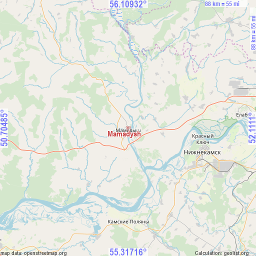
Mamadysh GPS coordinates[2]
55° 42' 54.9" North, 51° 24' 28.692" East
| Map corner | latitude | longitude |
|---|---|---|
| Upper-left | 56.10932°, | 50.70485° |
| Center: | 55.71525°, | 51.40797° |
| Lower-right: | 55.31716°, | 52.1111° |
| Map W x H: | 88.1×88.1 km | = 54.7×54.7mi |
| max Lat: | 73.50819° ⇑38.1% North |
| Mamadysh: | 55.71525° |
| min Lat: | ⇓61.9% South 41.28413° |
| min Long | Mamadysh | max Long |
| -179.12198° | 51.40797° | 179.35046° |
| W 63.4%⇐ | ⇒36.6% E |
Elevation
Elevation of Mamadysh is 90 m = 295 ft, and this is 112.6 m = 369 ft below average elevation for this country.
| Max E: |
2518 m = 8261 ft | 74.4% |
| Avg. | 202.6 m = 665 ft | |
| Mamadysh | 90 m = 295 ft | |
Min E: |
-28 m = -92 ft | 25.6% |
See also: Russia elevation on elevation.city.
Geographical zone
Mamadysh is located in North temperate zone (between Tropic of Cancer and the Arctic Circle). Distance of this North polar circle is 1206.2 km =749.5 mi to North.| Distance of | km | miles | from Mamadysh |
|---|---|---|---|
| North Pole | 3812.1 | 2368.7 | to North |
| Arctic Circle | 1206.2 | 749.5 | to North |
| Tropic Cancer | 3589 | 2230.1 | to South |
| Equator | 6195 | 3849.4 | to South |


Nearby cities:
15 places around Mamadysh: (largest is in red/bold)
• Bogatyye Saby
68.3 km =42.4 mi,  298°
298°
• Chistopol’
62.1 km =38.6 mi,  230°
230°
• Grakhovo
51 km =31.7 mi,  43°
43°
• Kizner
62.5 km =38.8 mi,  5°
5°
• Krasnaya Polyana
60.8 km =37.8 mi,  344°
344°
• Kukmor
61.3 km =38.1 mi,  328°
328°
• Lubyany
35.9 km =22.3 mi,  359°
359°
• Mendeleyevsk
59.2 km =36.8 mi,  68°
68°
• Naberezhnyye Chelny
62.8 km =39 mi,  88°
88°
• Nizhnekamsk
27.5 km =17.1 mi,  108°
108°
• Novosheshminsk
73.1 km =45.4 mi,  188°
188°
• Sosnovka
60.5 km =37.6 mi,  352°
352°
• Vyatskiye Polyany
60.7 km =37.7 mi, 339°
• Yelabuga
41.4 km =25.7 mi,  82°
82°
• Zainsk
60.6 km =37.7 mi,  136°
136°
In other languages:
- In France: Mamadych
- In German: Mamadysch
- In Italian: Mamadyš
- In Russian: Мамадыш
- In Chinese: 馬馬德什
Sources, notices
• [Note1] Compared only with cities in Russia existing in our database
• [Src1] Map data: © OpenStreetMap contributors (CC-BY-SA)
• [Src2] Other city data from geonames.org with taken over terms of usage.
• [Src3] Geographical zone / Annual Mean Temperature by Robert A. Rohde @ Wikipedia
