Chistopol’ geodata
Chistopol’ (Tatarstan Republic) is a populated place; located in Russia in Europe/Moscow (GMT+3) time zone. With population of 62,200 people, there are 330 cities with bigger population in this country. Compared to other cities in Russia, 56.8% of cities are located further ↓South; 62.7% of cities are located further ←West and 68.2% of cities have higher elevation than Chistopol’. Note1


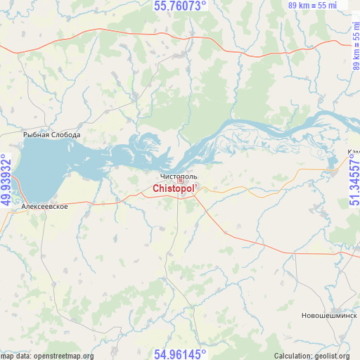
Chistopol’ GPS coordinates[2]
55° 21' 47.196" North, 50° 38' 32.784" East
| Map corner | latitude | longitude |
|---|---|---|
| Upper-left | 55.76073°, | 49.93932° |
| Center: | 55.36311°, | 50.64244° |
| Lower-right: | 54.96145°, | 51.34557° |
| Map W x H: | 88.9×88.9 km | = 55.2×55.2mi |
| max Lat: | 73.50819° ⇑43.2% North |
| Chistopol’: | 55.36311° |
| min Lat: | ⇓56.8% South 41.28413° |
| min Long | Chistopol’ | max Long |
| -179.12198° | 50.64244° | 179.35046° |
| W 62.7%⇐ | ⇒37.3% E |
Elevation
Elevation of Chistopol’ is 107 m = 351 ft, and this is 95.6 m = 314 ft below average elevation for this country.
| Max E: |
2518 m = 8261 ft | 68.2% |
| Avg. | 202.6 m = 665 ft | |
| Chistopol’ | 107 m = 351 ft | |
Min E: |
-28 m = -92 ft | 31.8% |
See also: Chistopol’ elevation on elevation.city.
Geographical zone
Chistopol’ is located in North temperate zone (between Tropic of Cancer and the Arctic Circle). Distance of this North polar circle is 1245.4 km =773.9 mi to North.| Distance of | km | miles | from Chistopol’ |
|---|---|---|---|
| North Pole | 3851.3 | 2393.1 | to North |
| Arctic Circle | 1245.4 | 773.9 | to North |
| Tropic Cancer | 3549.9 | 2205.8 | to South |
| Equator | 6155.8 | 3825 | to South |


Nearby cities:
15 places around Chistopol’: (largest is in red/bold)
• Alekseyevskoye
34 km =21.1 mi,  259°
259°
• Bazarnyye Mataki
69.8 km =43.4 mi,  220°
220°
• Bilyarsk
45.2 km =28.1 mi,  201°
201°
• Bogatyye Saby
73 km =45.4 mi,  350°
350°
• Kukmor
92.8 km =57.7 mi,  9°
9°
• Laishevo
69.1 km =42.9 mi,  273°
273°
• Lubyany
88.8 km =55.2 mi,  32°
32°
• Mamadysh
62.1 km =38.6 mi,  50°
50°
• Nizhnekamsk
80.4 km =50 mi,  67°
67°
• Novosheshminsk
50 km =31.1 mi,  131°
131°
• Pestretsy
75.8 km =47.1 mi,  304°
304°
• Rybnaya Sloboda
33.5 km =20.8 mi,  289°
289°
• Shemordan
92.7 km =57.6 mi, 350°
• Tyulyachi
63.9 km =39.7 mi,  336°
336°
• Zainsk
90.4 km =56.2 mi,  93°
93°
Sources, notices
• [Note1] Compared only with cities in Russia existing in our database
• [Src1] Map data: © OpenStreetMap contributors (CC-BY-SA)
• [Src2] Other city data from geonames.org with taken over terms of usage.
• [Src3] Geographical zone / Annual Mean Temperature by Robert A. Rohde @ Wikipedia
