Novosheshminsk geodata
Novosheshminsk (Tatarstan Republic) is a populated place; located in Russia in Europe/Moscow (GMT+3) time zone. With population of 4,585 people, there are 2829 cities with bigger population in this country. Compared to other cities in Russia, 54.1% of cities are located further ↓South; 63.3% of cities are located further ←West and 82% of cities have higher elevation than Novosheshminsk. Note1


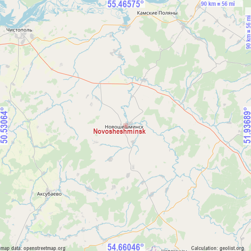
Novosheshminsk GPS coordinates[2]
55° 3' 54.468" North, 51° 14' 1.536" East
| Map corner | latitude | longitude |
|---|---|---|
| Upper-left | 55.46575°, | 50.53064° |
| Center: | 55.06513°, | 51.23376° |
| Lower-right: | 54.66046°, | 51.93689° |
| Map W x H: | 89.5×89.5 km | = 55.6×55.6mi |
| max Lat: | 73.50819° ⇑45.9% North |
| Novosheshminsk: | 55.06513° |
| min Lat: | ⇓54.1% South 41.28413° |
| min Long | Novosheshminsk | max Long |
| -179.12198° | 51.23376° | 179.35046° |
| W 63.3%⇐ | ⇒36.7% E |
Elevation
Elevation of Novosheshminsk is 63 m = 207 ft, and this is 139.6 m = 458 ft below average elevation for this country.
| Max E: |
2518 m = 8261 ft | 82% |
| Avg. | 202.6 m = 665 ft | |
| Novosheshminsk | 63 m = 207 ft | |
Min E: |
-28 m = -92 ft | 18% |
See also: Russia elevation on elevation.city.
Geographical zone
Novosheshminsk is located in North temperate zone (between Tropic of Cancer and the Arctic Circle). Distance of this North polar circle is 1278.5 km =794.4 mi to North.| Distance of | km | miles | from Novosheshminsk |
|---|---|---|---|
| North Pole | 3884.4 | 2413.7 | to North |
| Arctic Circle | 1278.5 | 794.4 | to North |
| Tropic Cancer | 3516.7 | 2185.2 | to South |
| Equator | 6122.7 | 3804.5 | to South |


Nearby cities:
15 places around Novosheshminsk: (largest is in red/bold)
• Alekseyevskoye
76 km =47.2 mi,  290°
290°
• Al’met’yevsk
71.3 km =44.3 mi,  104°
104°
• Bilyarsk
54.7 km =34 mi,  260°
260°
• Chelno-Vershiny
72.9 km =45.3 mi,  187°
187°
• Cheremshan
47.5 km =29.5 mi,  158°
158°
• Chistopol’
50 km =31.1 mi,  311°
311°
• Mamadysh
73.1 km =45.4 mi,  8°
8°
• Nizhnekamsk
73.7 km =45.8 mi,  30°
30°
• Nizhnyaya Maktama
79.5 km =49.4 mi,  106°
106°
• Nurlat
76 km =47.2 mi,  201°
201°
• Russkiy Aktash
56.6 km =35.2 mi,  93°
93°
• Rybnaya Sloboda
82.1 km =51 mi,  302°
302°
• Shentala
70.2 km =43.6 mi,  166°
166°
• Shugurovo
84.6 km =52.6 mi,  137°
137°
• Zainsk
60.1 km =37.3 mi,  61°
61°
Sources, notices
• [Note1] Compared only with cities in Russia existing in our database
• [Src1] Map data: © OpenStreetMap contributors (CC-BY-SA)
• [Src2] Other city data from geonames.org with taken over terms of usage.
• [Src3] Geographical zone / Annual Mean Temperature by Robert A. Rohde @ Wikipedia
