Kizner geodata
Kizner (Udmurtiya Republic) is a populated place; located in Russia in Europe/Samara (GMT+4) time zone. With population of 9,847 people, there are 1533 cities with bigger population in this country. Compared to other cities in Russia, 70.2% of cities are located further ↓South; 63.5% of cities are located further ←West and 78.4% of cities have higher elevation than Kizner. Note1


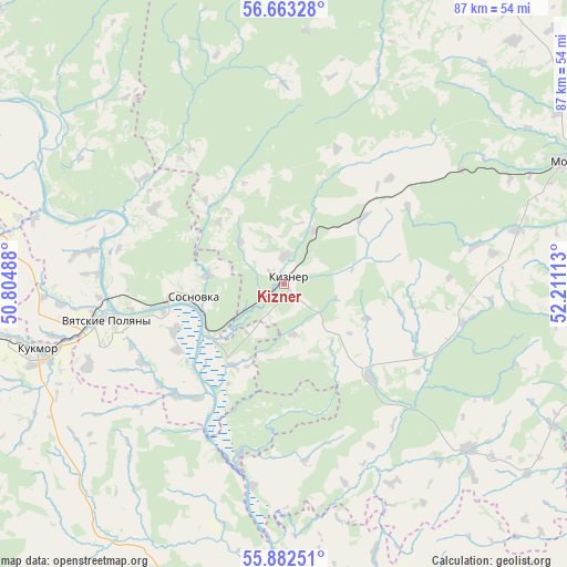
Kizner GPS coordinates[2]
56° 16' 29.604" North, 51° 30' 28.8" East
| Map corner | latitude | longitude |
|---|---|---|
| Upper-left | 56.66328°, | 50.80488° |
| Center: | 56.27489°, | 51.508° |
| Lower-right: | 55.88251°, | 52.21113° |
| Map W x H: | 86.8×86.8 km | = 53.9×53.9mi |
| max Lat: | 73.50819° ⇑29.8% North |
| Kizner: | 56.27489° |
| min Lat: | ⇓70.2% South 41.28413° |
| min Long | Kizner | max Long |
| -179.12198° | 51.508° | 179.35046° |
| W 63.5%⇐ | ⇒36.5% E |
Elevation
Elevation of Kizner is 76 m = 249 ft, and this is 126.6 m = 415 ft below average elevation for this country.
| Max E: |
2518 m = 8261 ft | 78.4% |
| Avg. | 202.6 m = 665 ft | |
| Kizner | 76 m = 249 ft | |
Min E: |
-28 m = -92 ft | 21.6% |
See also: Russia elevation on elevation.city.
Geographical zone
Kizner is located in North temperate zone (between Tropic of Cancer and the Arctic Circle). Distance of this North polar circle is 1144 km =710.8 mi to North.| Distance of | km | miles | from Kizner |
|---|---|---|---|
| North Pole | 3749.9 | 2330.1 | to North |
| Arctic Circle | 1144 | 710.8 | to North |
| Tropic Cancer | 3651.3 | 2268.8 | to South |
| Equator | 6257.2 | 3888 | to South |


Nearby cities:
15 places around Kizner: (largest is in red/bold)
• Alnashi
60.8 km =37.8 mi,  99°
99°
• Grakhovo
37.9 km =23.5 mi,  131°
131°
• Krasnaya Polyana
22.8 km =14.2 mi,  260°
260°
• Kukmor
39.2 km =24.4 mi, 255°
• Lubyany
27.2 km =16.9 mi,  194°
194°
• Malmyzh
57.7 km =35.9 mi,  298°
298°
• Mamadysh
62.5 km =38.8 mi, 185°
• Mendeleyevsk
63.4 km =39.4 mi, 130°
• Mozhga
48.2 km =30 mi,  66°
66°
• Pychas
62.8 km =39 mi, 66°
• Shemordan
69.4 km =43.1 mi, 261°
• Sosnovka
14 km =8.7 mi, 260°
• Vavozh
61.4 km =38.2 mi,  25°
25°
• Vyatskiye Polyany
27.9 km =17.3 mi, 258°
• Yelabuga
66.8 km =41.5 mi,  148°
148°
Sources, notices
• [Note1] Compared only with cities in Russia existing in our database
• [Src1] Map data: © OpenStreetMap contributors (CC-BY-SA)
• [Src2] Other city data from geonames.org with taken over terms of usage.
• [Src3] Geographical zone / Annual Mean Temperature by Robert A. Rohde @ Wikipedia
