Magnitka geodata
Magnitka (Chelyabinsk) is a populated place; located in Russia in Asia/Yekaterinburg (GMT+5) time zone. With population of 5,784 people, there are 2337 cities with bigger population in this country. Compared to other cities in Russia, 56.7% of cities are located further ↓South; 71% of cities are located further ←West and 87.6% of cities have lower elevation than Magnitka. Note1


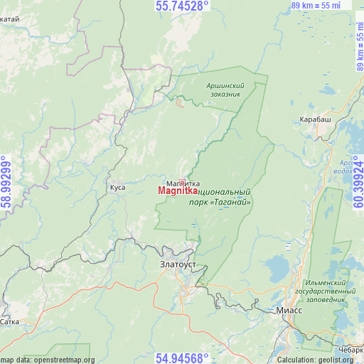
Magnitka GPS coordinates[2]
55° 20' 51" North, 59° 41' 45.996" East
| Map corner | latitude | longitude |
|---|---|---|
| Upper-left | 55.74528°, | 58.99299° |
| Center: | 55.3475°, | 59.69611° |
| Lower-right: | 54.94568°, | 60.39924° |
| Map W x H: | 88.9×88.9 km | = 55.2×55.2mi |
| max Lat: | 73.50819° ⇑43.3% North |
| Magnitka: | 55.3475° |
| min Lat: | ⇓56.7% South 41.28413° |
| min Long | Magnitka | max Long |
| -179.12198° | 59.69611° | 179.35046° |
| W 71%⇐ | ⇒29% E |
Elevation
Elevation of Magnitka is 386 m = 1266 ft, and this is 183.4 m = 602 ft above average elevation for this country.
| Max E: |
2518 m = 8261 ft | 12.4% |
| Magnitka | 386 m 1266 ft | |
| Avg. | 202.6 m = 665 ft | |
Min E: |
-28 m = -92 ft | 87.6% |
See also: Russia elevation on elevation.city.
Geographical zone
Magnitka is located in North temperate zone (between Tropic of Cancer and the Arctic Circle). Distance of this North polar circle is 1247.1 km =774.9 mi to North.| Distance of | km | miles | from Magnitka |
|---|---|---|---|
| North Pole | 3853 | 2394.1 | to North |
| Arctic Circle | 1247.1 | 774.9 | to North |
| Tropic Cancer | 3548.1 | 2204.7 | to South |
| Equator | 6154.1 | 3824 | to South |


Nearby cities:
15 places around Magnitka: (largest is in red/bold)
• Berdyaush
40.5 km =25.2 mi,  239°
239°
• Chebarkul’
59.3 km =36.8 mi,  134°
134°
• Karabash
36 km =22.4 mi,  65°
65°
• Kusa
16.2 km =10.1 mi,  266°
266°
• Leninsk
50.6 km =31.4 mi,  167°
167°
• Mezhevoy
61.2 km =38 mi,  251°
251°
• Miass
42.6 km =26.5 mi,  142°
142°
• Nizhniy Ufaley
65.7 km =40.8 mi,  15°
15°
• Novobelokatay
61.4 km =38.2 mi,  310°
310°
• Satka
53.7 km =33.4 mi,  230°
230°
• Syrostan
34.1 km =21.2 mi,  157°
157°
• Tayginka
59.7 km =37.1 mi,  58°
58°
• Turgoyak
34.6 km =21.5 mi, 129°
• Uvil’dy
59.2 km =36.8 mi, 70°
• Zlatoust
19.8 km =12.3 mi,  188°
188°
Sources, notices
• [Note1] Compared only with cities in Russia existing in our database
• [Src1] Map data: © OpenStreetMap contributors (CC-BY-SA)
• [Src2] Other city data from geonames.org with taken over terms of usage.
• [Src3] Geographical zone / Annual Mean Temperature by Robert A. Rohde @ Wikipedia
