Chebarkul’ geodata
Chebarkul’ (Chelyabinsk) is a populated place; located in Russia in Asia/Yekaterinburg (GMT+5) time zone. With population of 46,502 people, there are 453 cities with bigger population in this country. Compared to other cities in Russia, 53% of cities are located further ↓South; 72.3% of cities are located further ←West and 85.4% of cities have lower elevation than Chebarkul’. Note1


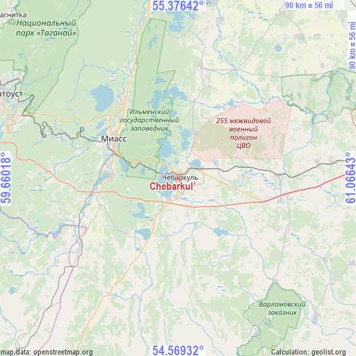
Chebarkul’ GPS coordinates[2]
54° 58' 29.64" North, 60° 21' 47.88" East
| Map corner | latitude | longitude |
|---|---|---|
| Upper-left | 55.37642°, | 59.66018° |
| Center: | 54.9749°, | 60.3633° |
| Lower-right: | 54.56932°, | 61.06643° |
| Map W x H: | 89.7×89.7 km | = 55.7×55.7mi |
| max Lat: | 73.50819° ⇑47% North |
| Chebarkul’: | 54.9749° |
| min Lat: | ⇓53% South 41.28413° |
| min Long | Chebarkul’ | max Long |
| -179.12198° | 60.3633° | 179.35046° |
| W 72.3%⇐ | ⇒27.7% E |
Elevation
Elevation of Chebarkul’ is 329 m = 1079 ft, and this is 126.4 m = 415 ft above average elevation for this country.
| Max E: |
2518 m = 8261 ft | 14.6% |
| Chebarkul’ | 329 m 1079 ft | |
| Avg. | 202.6 m = 665 ft | |
Min E: |
-28 m = -92 ft | 85.4% |
See also: Chebarkul’ elevation on elevation.city.
Geographical zone
Chebarkul’ is located in North temperate zone (between Tropic of Cancer and the Arctic Circle). Distance of this North polar circle is 1288.5 km =800.6 mi to North.| Distance of | km | miles | from Chebarkul’ |
|---|---|---|---|
| North Pole | 3894.4 | 2419.9 | to North |
| Arctic Circle | 1288.5 | 800.6 | to North |
| Tropic Cancer | 3506.7 | 2179 | to South |
| Equator | 6112.6 | 3798.2 | to South |


Nearby cities:
15 places around Chebarkul’: (largest is in red/bold)
• Argayash
65.8 km =40.9 mi,  29°
29°
• Karabash
57 km =35.4 mi,  350°
350°
• Koyelga
49.9 km =31 mi,  135°
135°
• Leninsk
32.7 km =20.3 mi,  255°
255°
• Magnitka
59.3 km =36.8 mi,  314°
314°
• Miass
18 km =11.2 mi,  295°
295°
• Novosineglazovskiy
65 km =40.4 mi,  83°
83°
• Poletayevo
48.3 km =30 mi, 82°
• Sargazy
56.8 km =35.3 mi, 84°
• Syrostan
31.1 km =19.3 mi,  288°
288°
• Timiryazevskiy
26 km =16.2 mi,  101°
101°
• Turgoyak
24.9 km =15.5 mi,  321°
321°
• Uvil’dy
63.1 km =39.2 mi,  12°
12°
• Yemanzhelinka
62.9 km =39.1 mi,  107°
107°
• Zlatoust
50.3 km =31.3 mi, 295°
Sources, notices
• [Note1] Compared only with cities in Russia existing in our database
• [Src1] Map data: © OpenStreetMap contributors (CC-BY-SA)
• [Src2] Other city data from geonames.org with taken over terms of usage.
• [Src3] Geographical zone / Annual Mean Temperature by Robert A. Rohde @ Wikipedia
