Lyudinovo geodata
Lyudinovo (Kaluga) is a populated place; located in Russia in Europe/Moscow (GMT+3) time zone. With population of 41,392 people, there are 509 cities with bigger population in this country. Compared to other cities in Russia, 56.3% of cities are located further ↑North; 89.8% of cities are located further →East and 65% of cities have lower elevation than Lyudinovo. Note1


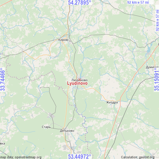
Lyudinovo GPS coordinates[2]
53° 51' 59.004" North, 34° 26' 52.008" East
| Map corner | latitude | longitude |
|---|---|---|
| Upper-left | 54.27895°, | 33.74466° |
| Center: | 53.86639°, | 34.44778° |
| Lower-right: | 53.44972°, | 35.15091° |
| Map W x H: | 92.2×92.2 km | = 57.3×57.3mi |
| max Lat: | 73.50819° ⇑56.3% North |
| Lyudinovo: | 53.86639° |
| min Lat: | ⇓43.7% South 41.28413° |
| min Long | Lyudinovo | max Long |
| -179.12198° | 34.44778° | 179.35046° |
| W 10.2%⇐ | ⇒89.8% E |
Elevation
Elevation of Lyudinovo is 182 m = 597 ft, and this is 20.6 m = 68 ft below average elevation for this country.
| Max E: |
2518 m = 8261 ft | 35% |
| Avg. | 202.6 m = 665 ft | |
| Lyudinovo | 182 m = 597 ft | |
Min E: |
-28 m = -92 ft | 65% |
See also: Lyudinovo elevation on elevation.city.
Geographical zone
Lyudinovo is located in North temperate zone (between Tropic of Cancer and the Arctic Circle). Distance of this North polar circle is 1411.8 km =877.3 mi to North.| Distance of | km | miles | from Lyudinovo |
|---|---|---|---|
| North Pole | 4017.7 | 2496.5 | to North |
| Arctic Circle | 1411.8 | 877.3 | to North |
| Tropic Cancer | 3383.5 | 2102.4 | to South |
| Equator | 5989.4 | 3721.6 | to South |


Nearby cities:
15 places around Lyudinovo: (largest is in red/bold)
• Baryatino
49.8 km =30.9 mi,  5°
5°
• Betlitsa
35.7 km =22.2 mi,  296°
296°
• Bytosh’
24 km =14.9 mi,  257°
257°
• Duminichi
44 km =27.3 mi,  80°
80°
• Dyat’kovo
30.7 km =19.1 mi,  193°
193°
• Ivanovka
59.7 km =37.1 mi, 194°
• Ivot
27.3 km =17 mi,  218°
218°
• Kirov
24.3 km =15.1 mi,  336°
336°
• Lyubokhna
40.6 km =25.2 mi, 185°
• Rognedino
58.9 km =36.6 mi, 262°
• Rzhanitsa
59.7 km =37.1 mi, 215°
• Sel’tso
59.9 km =37.2 mi,  202°
202°
• Seredeyskiy
55.2 km =34.3 mi,  68°
68°
• Star’
33.3 km =20.7 mi, 215°
• Zhizdra
23.4 km =14.5 mi,  124°
124°
Sources, notices
• [Note1] Compared only with cities in Russia existing in our database
• [Src1] Map data: © OpenStreetMap contributors (CC-BY-SA)
• [Src2] Other city data from geonames.org with taken over terms of usage.
• [Src3] Geographical zone / Annual Mean Temperature by Robert A. Rohde @ Wikipedia
