Bytosh’ geodata
Bytosh’ (Bryansk Oblast) is a populated place; located in Russia in Europe/Moscow (GMT+3) time zone. With population of 4,425 people, there are 2901 cities with bigger population in this country. Compared to other cities in Russia, 56.6% of cities are located further ↑North; 90.4% of cities are located further →East and 65.9% of cities have lower elevation than Bytosh’. Note1


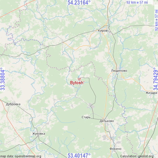
Bytosh’ GPS coordinates[2]
53° 49' 6.996" North, 34° 5' 28.176" East
| Map corner | latitude | longitude |
|---|---|---|
| Upper-left | 54.23164°, | 33.38804° |
| Center: | 53.81861°, | 34.09116° |
| Lower-right: | 53.40147°, | 34.79429° |
| Map W x H: | 92.3×92.3 km | = 57.4×57.4mi |
| max Lat: | 73.50819° ⇑56.6% North |
| Bytosh’: | 53.81861° |
| min Lat: | ⇓43.4% South 41.28413° |
| min Long | Bytosh’ | max Long |
| -179.12198° | 34.09116° | 179.35046° |
| W 9.6%⇐ | ⇒90.4% E |
Elevation
Elevation of Bytosh’ is 184 m = 604 ft, and this is 18.6 m = 61 ft below average elevation for this country.
| Max E: |
2518 m = 8261 ft | 34.1% |
| Avg. | 202.6 m = 665 ft | |
| Bytosh’ | 184 m = 604 ft | |
Min E: |
-28 m = -92 ft | 65.9% |
See also: Russia elevation on elevation.city.
Geographical zone
Bytosh’ is located in North temperate zone (between Tropic of Cancer and the Arctic Circle). Distance of this North polar circle is 1417.1 km =880.5 mi to North.| Distance of | km | miles | from Bytosh’ |
|---|---|---|---|
| North Pole | 4023 | 2499.8 | to North |
| Arctic Circle | 1417.1 | 880.5 | to North |
| Tropic Cancer | 3378.1 | 2099.1 | to South |
| Equator | 5984.1 | 3718.3 | to South |


Nearby cities:
15 places around Bytosh’: (largest is in red/bold)
• Betlitsa
22.9 km =14.2 mi,  337°
337°
• Dubrovka
40.9 km =25.4 mi,  249°
249°
• Dyat’kovo
29.4 km =18.3 mi,  146°
146°
• Ivot
17.1 km =10.6 mi,  158°
158°
• Kirov
30.8 km =19.1 mi,  26°
26°
• Lyubokhna
40.2 km =25 mi, 150°
• Lyudinovo
24 km =14.9 mi,  77°
77°
• Ovstug
52.1 km =32.4 mi,  195°
195°
• Rognedino
35.1 km =21.8 mi,  266°
266°
• Rzhanitsa
44.8 km =27.8 mi,  194°
194°
• Sel’tso
50.1 km =31.1 mi,  179°
179°
• Seshcha
50.3 km =31.3 mi,  259°
259°
• Star’
22 km =13.7 mi,  169°
169°
• Zhizdra
43.4 km =27 mi,  100°
100°
• Zhukovka
39.7 km =24.7 mi,  217°
217°
Sources, notices
• [Note1] Compared only with cities in Russia existing in our database
• [Src1] Map data: © OpenStreetMap contributors (CC-BY-SA)
• [Src2] Other city data from geonames.org with taken over terms of usage.
• [Src3] Geographical zone / Annual Mean Temperature by Robert A. Rohde @ Wikipedia
