Lechinkay geodata
Lechinkay (Kabardino-Balkariya Republic) is a populated place; located in Russia in Europe/Moscow (GMT+3) time zone. With population of 4,334 people, there are 2934 cities with bigger population in this country. Compared to other cities in Russia, 93.6% of cities are located further ↑North; 54.9% of cities are located further →East and 96.5% of cities have lower elevation than Lechinkay. Note1


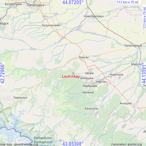
Lechinkay GPS coordinates[2]
43° 33' 52.992" North, 43° 25' 58.008" East
| Map corner | latitude | longitude |
|---|---|---|
| Upper-left | 44.07205°, | 42.72966° |
| Center: | 43.56472°, | 43.43278° |
| Lower-right: | 43.05308°, | 44.13591° |
| Map W x H: | 113.3×113.3 km | = 70.4×70.4mi |
| max Lat: | 73.50819° ⇑93.6% North |
| Lechinkay: | 43.56472° |
| min Lat: | ⇓6.4% South 41.28413° |
| min Long | Lechinkay | max Long |
| -179.12198° | 43.43278° | 179.35046° |
| W 45.1%⇐ | ⇒54.9% E |
Elevation
Elevation of Lechinkay is 726 m = 2382 ft, and this is 523.4 m = 1717 ft above average elevation for this country.
| Max E: |
2518 m = 8261 ft | 3.5% |
| Lechinkay | 726 m 2382 ft | |
| Avg. | 202.6 m = 665 ft | |
Min E: |
-28 m = -92 ft | 96.5% |
See also: Russia elevation on elevation.city.
Geographical zone
Lechinkay is located in North temperate zone (between Tropic of Cancer and the Arctic Circle). Distance of this Northern Tropic circle is 2238 km =1390.6 mi to South.| Distance of | km | miles | from Lechinkay |
|---|---|---|---|
| North Pole | 5163.1 | 3208.2 | to North |
| Arctic Circle | 2557.2 | 1589 | to North |
| Tropic Cancer | 2238 | 1390.6 | to South |
| Equator | 4843.9 | 3009.9 | to South |


Nearby cities:
15 places around Lechinkay: (largest is in red/bold)
• Baksan
16.1 km =10 mi,  31°
31°
• Belaya Rechka
16.3 km =10.1 mi,  149°
149°
• Chegem Vtoroy
13.9 km =8.6 mi,  75°
75°
• Dugulubgey
13.7 km =8.5 mi,  37°
37°
• Islamey
12.5 km =7.8 mi,  8°
8°
• Kamenka
7.6 km =4.7 mi,  117°
117°
• Kenzhe
12.2 km =7.6 mi, 124°
• Kyzburun Pervyy
10.1 km =6.3 mi,  342°
342°
• Lashkuta
18.8 km =11.7 mi,  265°
265°
• Nal’chik
16.7 km =10.4 mi, 116°
• Shalushka
11.3 km =7 mi,  108°
108°
• Verkhniy Kurkuzhin
19.3 km =12 mi,  318°
318°
• Vol’nyy Aul
18.4 km =11.4 mi, 121°
• Zayukovo
9.8 km =6.1 mi,  305°
305°
• Zhankhoteko
17.9 km =11.1 mi, 269°
Sources, notices
• [Note1] Compared only with cities in Russia existing in our database
• [Src1] Map data: © OpenStreetMap contributors (CC-BY-SA)
• [Src2] Other city data from geonames.org with taken over terms of usage.
• [Src3] Geographical zone / Annual Mean Temperature by Robert A. Rohde @ Wikipedia
