Verkhniy Kurkuzhin geodata
Verkhniy Kurkuzhin (Kabardino-Balkariya Republic) is a populated place; located in Russia in Europe/Moscow (GMT+3) time zone. With population of 3,129 people, there are 3670 cities with bigger population in this country. Compared to other cities in Russia, 93.1% of cities are located further ↑North; 55.5% of cities are located further →East and 97.3% of cities have lower elevation than Verkhniy Kurkuzhin. Note1


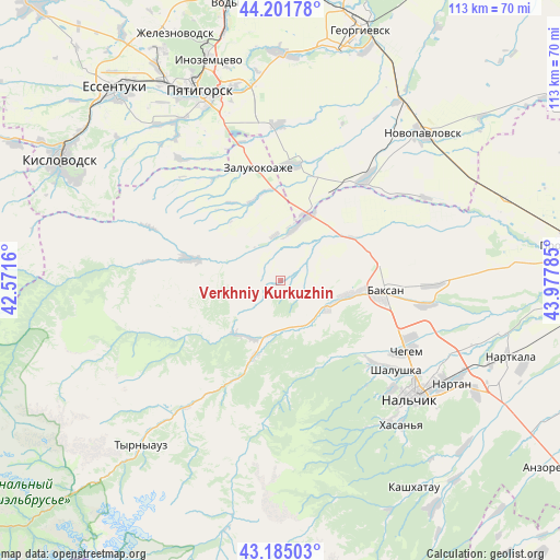
Verkhniy Kurkuzhin GPS coordinates[2]
43° 41' 44.016" North, 43° 16' 28.992" East
| Map corner | latitude | longitude |
|---|---|---|
| Upper-left | 44.20178°, | 42.5716° |
| Center: | 43.69556°, | 43.27472° |
| Lower-right: | 43.18503°, | 43.97785° |
| Map W x H: | 113.1×113.1 km | = 70.3×70.3mi |
| max Lat: | 73.50819° ⇑93.1% North |
| Verkhniy Kurkuzhin: | 43.69556° |
| min Lat: | ⇓6.9% South 41.28413° |
| min Long | Verkhniy Kurkuz | max Long |
| -179.12198° | 43.27472° | 179.35046° |
| W 44.5%⇐ | ⇒55.5% E |
Elevation
Elevation of Verkhniy Kurkuzhin is 804 m = 2638 ft, and this is 601.4 m = 1973 ft above average elevation for this country.
| Max E: |
2518 m = 8261 ft | 2.7% |
| Verkhniy Kurkuzhin | 804 m 2638 ft | |
| Avg. | 202.6 m = 665 ft | |
Min E: |
-28 m = -92 ft | 97.3% |
See also: Russia elevation on elevation.city.
Geographical zone
Verkhniy Kurkuzhin is located in North temperate zone (between Tropic of Cancer and the Arctic Circle). Distance of this Northern Tropic circle is 2252.6 km =1399.7 mi to South.| Distance of | km | miles | from Verkhniy Kurkuzhin |
|---|---|---|---|
| North Pole | 5148.6 | 3199.2 | to North |
| Arctic Circle | 2542.7 | 1580 | to North |
| Tropic Cancer | 2252.6 | 1399.7 | to South |
| Equator | 4858.5 | 3018.9 | to South |


Nearby cities:
15 places around Verkhniy Kurkuzhin: (largest is in red/bold)
• Baksan
21.1 km =13.1 mi,  92°
92°
• Dugulubgey
21.4 km =13.3 mi,  99°
99°
• Gundelen
13.7 km =8.5 mi,  217°
217°
• Islamey
14.7 km =9.1 mi, 98°
• Kamennomostskoye
18.5 km =11.5 mi,  284°
284°
• Kuba-Taba
16.2 km =10.1 mi,  56°
56°
• Kyzburun Pervyy
10.8 km =6.7 mi,  116°
116°
• Lashkuta
17.3 km =10.7 mi,  200°
200°
• Lechinkay
19.3 km =12 mi,  138°
138°
• Malka
12.7 km =7.9 mi,  18°
18°
• Nizhniy Kurkuzhin
8.4 km =5.2 mi,  45°
45°
• Sarmakovo
8.2 km =5.1 mi,  312°
312°
• Zalukokoazhe
23.6 km =14.7 mi,  348°
348°
• Zayukovo
10 km =6.2 mi,  151°
151°
• Zhankhoteko
15.5 km =9.6 mi, 199°
Sources, notices
• [Note1] Compared only with cities in Russia existing in our database
• [Src1] Map data: © OpenStreetMap contributors (CC-BY-SA)
• [Src2] Other city data from geonames.org with taken over terms of usage.
• [Src3] Geographical zone / Annual Mean Temperature by Robert A. Rohde @ Wikipedia
