Baksan geodata
Baksan (Kabardino-Balkariya Republic) is a populated place; located in Russia in Europe/Moscow (GMT+3) time zone. With population of 37,519 people, there are 554 cities with bigger population in this country. Compared to other cities in Russia, 93.1% of cities are located further ↑North; 54.6% of cities are located further →East and 90% of cities have lower elevation than Baksan. Note1


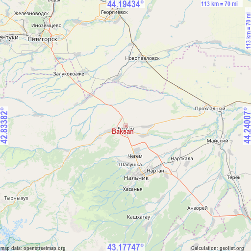
Baksan GPS coordinates[2]
43° 41' 17.016" North, 43° 32' 12.984" East
| Map corner | latitude | longitude |
|---|---|---|
| Upper-left | 44.19434°, | 42.83382° |
| Center: | 43.68806°, | 43.53694° |
| Lower-right: | 43.17747°, | 44.24007° |
| Map W x H: | 113.1×113.1 km | = 70.3×70.3mi |
| max Lat: | 73.50819° ⇑93.1% North |
| Baksan: | 43.68806° |
| min Lat: | ⇓6.9% South 41.28413° |
| min Long | Baksan | max Long |
| -179.12198° | 43.53694° | 179.35046° |
| W 45.4%⇐ | ⇒54.6% E |
Elevation
Elevation of Baksan is 451 m = 1480 ft, and this is 248.4 m = 815 ft above average elevation for this country.
| Max E: |
2518 m = 8261 ft | 10% |
| Baksan | 451 m 1480 ft | |
| Avg. | 202.6 m = 665 ft | |
Min E: |
-28 m = -92 ft | 90% |
See also: Russia elevation on elevation.city.
Geographical zone
Baksan is located in North temperate zone (between Tropic of Cancer and the Arctic Circle). Distance of this Northern Tropic circle is 2251.7 km =1399.1 mi to South.| Distance of | km | miles | from Baksan |
|---|---|---|---|
| North Pole | 5149.4 | 3199.7 | to North |
| Arctic Circle | 2543.5 | 1580.5 | to North |
| Tropic Cancer | 2251.7 | 1399.1 | to South |
| Equator | 4857.7 | 3018.4 | to South |


Nearby cities:
15 places around Baksan: (largest is in red/bold)
• Baksanenok
9.5 km =5.9 mi,  88°
88°
• Chegem Vtoroy
11.4 km =7.1 mi,  153°
153°
• Dugulubgey
2.8 km =1.7 mi,  180°
180°
• Islamey
6.7 km =4.2 mi,  258°
258°
• Kamenka
17.3 km =10.7 mi,  185°
185°
• Kenzhe
20.8 km =12.9 mi, 175°
• Kishpek
9.1 km =5.7 mi,  113°
113°
• Kuba-Taba
12.4 km =7.7 mi,  322°
322°
• Kyzburun Pervyy
12.1 km =7.5 mi,  250°
250°
• Lechinkay
16.1 km =10 mi,  211°
211°
• Nizhniy Kurkuzhin
16.5 km =10.3 mi,  294°
294°
• Shalushka
17.5 km =10.9 mi,  172°
172°
• Staropavlovskaya
19.5 km =12.1 mi,  23°
23°
• Verkhniy Kurkuzhin
21.1 km =13.1 mi,  272°
272°
• Zayukovo
18.2 km =11.3 mi,  243°
243°
Sources, notices
• [Note1] Compared only with cities in Russia existing in our database
• [Src1] Map data: © OpenStreetMap contributors (CC-BY-SA)
• [Src2] Other city data from geonames.org with taken over terms of usage.
• [Src3] Geographical zone / Annual Mean Temperature by Robert A. Rohde @ Wikipedia
