Lakhdenpokh’ya geodata
Lakhdenpokh’ya (Karelia) is a populated place; located in Russia in Europe/Moscow (GMT+3) time zone. With population of 8,448 people, there are 1726 cities with bigger population in this country. Compared to other cities in Russia, 94% of cities are located further ↓South; 96.5% of cities are located further →East and 94.5% of cities have higher elevation than Lakhdenpokh’ya. Note1


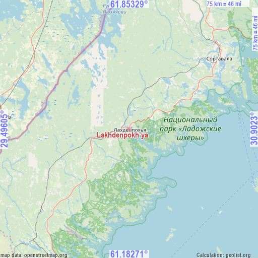
Lakhdenpokh’ya GPS coordinates[2]
61° 31' 11.316" North, 30° 11' 57.012" East
| Map corner | latitude | longitude |
|---|---|---|
| Upper-left | 61.85329°, | 29.49605° |
| Center: | 61.51981°, | 30.19917° |
| Lower-right: | 61.18271°, | 30.9023° |
| Map W x H: | 74.6×74.6 km | = 46.4×46.4mi |
| max Lat: | 73.50819° ⇑6% North |
| Lakhdenpokh’ya: | 61.51981° |
| min Lat: | ⇓94% South 41.28413° |
| min Long | Lakhdenpokh’y | max Long |
| -179.12198° | 30.19917° | 179.35046° |
| W 3.5%⇐ | ⇒96.5% E |
Elevation
Elevation of Lakhdenpokh’ya is 14 m = 46 ft, and this is 188.6 m = 619 ft below average elevation for this country.
| Max E: |
2518 m = 8261 ft | 94.5% |
| Avg. | 202.6 m = 665 ft | |
| Lakhdenpokh’ya | 14 m = 46 ft | |
Min E: |
-28 m = -92 ft | 5.5% |
See also: Russia elevation on elevation.city.
Geographical zone
Lakhdenpokh’ya is located in North temperate zone (between Tropic of Cancer and the Arctic Circle). Distance of this North polar circle is 560.8 km =348.5 mi to North.| Distance of | km | miles | from Lakhdenpokh’ya |
|---|---|---|---|
| North Pole | 3166.7 | 1967.7 | to North |
| Arctic Circle | 560.8 | 348.5 | to North |
| Tropic Cancer | 4234.4 | 2631.1 | to South |
| Equator | 6840.4 | 4250.4 | to South |


Nearby cities:
15 places around Lakhdenpokh’ya: (largest is in red/bold)
• Kamennogorsk
84.8 km =52.7 mi,  222°
222°
• Kharlu
50.4 km =31.3 mi,  51°
51°
• Khelyulya
35.4 km =22 mi,  43°
43°
• Khiitola
41.3 km =25.7 mi, 220°
• Kuznechnoye
48.2 km =30 mi,  201°
201°
• Lesogorskiy
85.9 km =53.4 mi,  232°
232°
• Losevo
81.3 km =50.5 mi, 233°
• Lyaskelya
50.5 km =31.4 mi,  57°
57°
• Pitkyaranta
68.1 km =42.3 mi,  84°
84°
• Priozërsk
53.6 km =33.3 mi,  184°
184°
• Ruskeala
50.2 km =31.2 mi,  23°
23°
• Sortavala
34.4 km =21.4 mi, 51°
• Svetogorsk
84.5 km =52.5 mi,  237°
237°
• Vyartsilya
77.5 km =48.2 mi, 19°
• Yanis’yarvi
57.1 km =35.5 mi, 43°
Sources, notices
• [Note1] Compared only with cities in Russia existing in our database
• [Src1] Map data: © OpenStreetMap contributors (CC-BY-SA)
• [Src2] Other city data from geonames.org with taken over terms of usage.
• [Src3] Geographical zone / Annual Mean Temperature by Robert A. Rohde @ Wikipedia
