Vyartsilya geodata
Vyartsilya (Karelia) is a populated place; located in Russia in Europe/Moscow (GMT+3) time zone. With population of 3,145 people, there are 3653 cities with bigger population in this country. Compared to other cities in Russia, 95.2% of cities are located further ↓South; 94.9% of cities are located further →East and 72.6% of cities have higher elevation than Vyartsilya. Note1


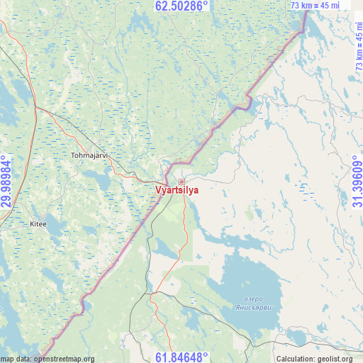
Vyartsilya GPS coordinates[2]
62° 10' 35.22" North, 30° 41' 34.656" East
| Map corner | latitude | longitude |
|---|---|---|
| Upper-left | 62.50286°, | 29.98984° |
| Center: | 62.17645°, | 30.69296° |
| Lower-right: | 61.84648°, | 31.39609° |
| Map W x H: | 73×73 km | = 45.4×45.4mi |
| max Lat: | 73.50819° ⇑4.8% North |
| Vyartsilya: | 62.17645° |
| min Lat: | ⇓95.2% South 41.28413° |
| min Long | Vyartsilya | max Long |
| -179.12198° | 30.69296° | 179.35046° |
| W 5.1%⇐ | ⇒94.9% E |
Elevation
Elevation of Vyartsilya is 95 m = 312 ft, and this is 107.6 m = 353 ft below average elevation for this country.
| Max E: |
2518 m = 8261 ft | 72.6% |
| Avg. | 202.6 m = 665 ft | |
| Vyartsilya | 95 m = 312 ft | |
Min E: |
-28 m = -92 ft | 27.4% |
See also: Russia elevation on elevation.city.
Geographical zone
Vyartsilya is located in North temperate zone (between Tropic of Cancer and the Arctic Circle). Distance of this North polar circle is 487.8 km =303.1 mi to North.| Distance of | km | miles | from Vyartsilya |
|---|---|---|---|
| North Pole | 3093.7 | 1922.3 | to North |
| Arctic Circle | 487.8 | 303.1 | to North |
| Tropic Cancer | 4307.5 | 2676.6 | to South |
| Equator | 6913.4 | 4295.8 | to South |


Nearby cities:
15 places around Vyartsilya: (largest is in red/bold)
• Gimoly
127 km =78.9 mi,  40°
40°
• Kharlu
44 km =27.3 mi,  162°
162°
• Khelyulya
47.6 km =29.6 mi,  181°
181°
• Khiitola
116.8 km =72.6 mi,  206°
206°
• Kuznechnoye
125.6 km =78 mi,  200°
200°
• Lakhdenpokh’ya
77.5 km =48.2 mi, 199°
• Lyaskelya
48.8 km =30.3 mi, 160°
• Pitkyaranta
78.7 km =48.9 mi,  148°
148°
• Porosozero
120.8 km =75.1 mi,  60°
60°
• Ruskeala
27.6 km =17.1 mi,  191°
191°
• Salmi
108.4 km =67.4 mi, 145°
• Sortavala
51.6 km =32.1 mi, 179°
• Suoyarvi
86.7 km =53.9 mi,  96°
96°
• Veshkelitsa
114 km =70.8 mi, 104°
• Yanis’yarvi
34.4 km =21.4 mi, 157°
Sources, notices
• [Note1] Compared only with cities in Russia existing in our database
• [Src1] Map data: © OpenStreetMap contributors (CC-BY-SA)
• [Src2] Other city data from geonames.org with taken over terms of usage.
• [Src3] Geographical zone / Annual Mean Temperature by Robert A. Rohde @ Wikipedia
