Kropachëvo geodata
Kropachëvo (Chelyabinsk) is a populated place; located in Russia in Asia/Yekaterinburg (GMT+5) time zone. With population of 5,252 people, there are 2530 cities with bigger population in this country. Compared to other cities in Russia, 53.4% of cities are located further ↓South; 69.5% of cities are located further ←West and 87.9% of cities have lower elevation than Kropachëvo. Note1


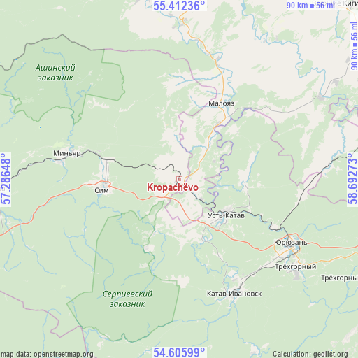
Kropachëvo GPS coordinates[2]
55° 0' 40.32" North, 57° 59' 22.56" East
| Map corner | latitude | longitude |
|---|---|---|
| Upper-left | 55.41236°, | 57.28648° |
| Center: | 55.0112°, | 57.9896° |
| Lower-right: | 54.60599°, | 58.69273° |
| Map W x H: | 89.7×89.7 km | = 55.7×55.7mi |
| max Lat: | 73.50819° ⇑46.6% North |
| Kropachëvo: | 55.0112° |
| min Lat: | ⇓53.4% South 41.28413° |
| min Long | Kropachëvo | max Long |
| -179.12198° | 57.9896° | 179.35046° |
| W 69.5%⇐ | ⇒30.5% E |
Elevation
Elevation of Kropachëvo is 397 m = 1302 ft, and this is 194.4 m = 638 ft above average elevation for this country.
| Max E: |
2518 m = 8261 ft | 12.1% |
| Kropachëvo | 397 m 1302 ft | |
| Avg. | 202.6 m = 665 ft | |
Min E: |
-28 m = -92 ft | 87.9% |
See also: Russia elevation on elevation.city.
Geographical zone
Kropachëvo is located in North temperate zone (between Tropic of Cancer and the Arctic Circle). Distance of this North polar circle is 1284.5 km =798.2 mi to North.| Distance of | km | miles | from Kropachëvo |
|---|---|---|---|
| North Pole | 3890.4 | 2417.4 | to North |
| Arctic Circle | 1284.5 | 798.2 | to North |
| Tropic Cancer | 3510.8 | 2181.5 | to South |
| Equator | 6116.7 | 3800.7 | to South |


Nearby cities:
15 places around Kropachëvo: (largest is in red/bold)
• Asha
45.8 km =28.5 mi,  268°
268°
• Bakal
52.8 km =32.8 mi,  98°
98°
• Katav-Ivanovsk
31.6 km =19.6 mi,  155°
155°
• Mesyagutovo
60.1 km =37.3 mi,  16°
16°
• Mezhevoy
53.4 km =33.2 mi,  70°
70°
• Mursalimkino
36.4 km =22.6 mi,  85°
85°
• Satka
67 km =41.6 mi, 87°
• Sim
18.7 km =11.6 mi,  263°
263°
• Trëkhgornyy
37.1 km =23.1 mi,  126°
126°
• Ulu-Telyak
65.1 km =40.5 mi, 260°
• Urman
72.6 km =45.1 mi, 258°
• Ust’-Katav
14.5 km =9 mi,  124°
124°
• Verkhniye Kigi
58.9 km =36.6 mi,  41°
41°
• Vyazovaya
26.2 km =16.3 mi, 116°
• Yuryuzan’
32.1 km =19.9 mi, 120°
Sources, notices
• [Note1] Compared only with cities in Russia existing in our database
• [Src1] Map data: © OpenStreetMap contributors (CC-BY-SA)
• [Src2] Other city data from geonames.org with taken over terms of usage.
• [Src3] Geographical zone / Annual Mean Temperature by Robert A. Rohde @ Wikipedia
