Verkhniye Kigi geodata
Verkhniye Kigi (Bashkortostan Republic) is a populated place; located in Russia in Asia/Yekaterinburg (GMT+5) time zone. With population of 6,885 people, there are 2030 cities with bigger population in this country. Compared to other cities in Russia, 57.2% of cities are located further ↓South; 70.1% of cities are located further ←West and 81.6% of cities have lower elevation than Verkhniye Kigi. Note1


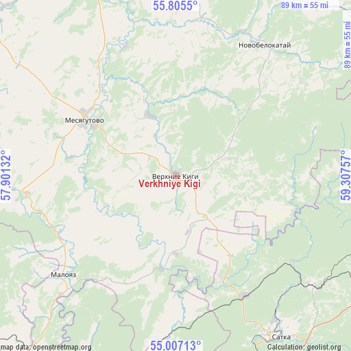
Verkhniye Kigi GPS coordinates[2]
55° 24' 29.988" North, 58° 36' 15.984" East
| Map corner | latitude | longitude |
|---|---|---|
| Upper-left | 55.8055°, | 57.90132° |
| Center: | 55.40833°, | 58.60444° |
| Lower-right: | 55.00713°, | 59.30757° |
| Map W x H: | 88.8×88.8 km | = 55.2×55.2mi |
| max Lat: | 73.50819° ⇑42.8% North |
| Verkhniye Kigi: | 55.40833° |
| min Lat: | ⇓57.2% South 41.28413° |
| min Long | Verkhniye Kigi | max Long |
| -179.12198° | 58.60444° | 179.35046° |
| W 70.1%⇐ | ⇒29.9% E |
Elevation
Elevation of Verkhniye Kigi is 269 m = 883 ft, and this is 66.4 m = 218 ft above average elevation for this country.
| Max E: |
2518 m = 8261 ft | 18.4% |
| Verkhniye Kigi | 269 m 883 ft | |
| Avg. | 202.6 m = 665 ft | |
Min E: |
-28 m = -92 ft | 81.6% |
See also: Russia elevation on elevation.city.
Geographical zone
Verkhniye Kigi is located in North temperate zone (between Tropic of Cancer and the Arctic Circle). Distance of this North polar circle is 1240.3 km =770.7 mi to North.| Distance of | km | miles | from Verkhniye Kigi |
|---|---|---|---|
| North Pole | 3846.2 | 2389.9 | to North |
| Arctic Circle | 1240.3 | 770.7 | to North |
| Tropic Cancer | 3554.9 | 2208.9 | to South |
| Equator | 6160.8 | 3828.1 | to South |


Nearby cities:
15 places around Verkhniye Kigi: (largest is in red/bold)
• Bakal
53.5 km =33.2 mi,  165°
165°
• Berdyaush
43.9 km =27.3 mi,  128°
128°
• Duvan
54.5 km =33.9 mi,  305°
305°
• Kropachëvo
58.9 km =36.6 mi,  221°
221°
• Kusa
53.4 km =33.2 mi,  98°
98°
• Magnitka
69.3 km =43.1 mi, 95°
• Mesyagutovo
26 km =16.2 mi,  301°
301°
• Mezhevoy
28.7 km =17.8 mi,  156°
156°
• Mursalimkino
41.3 km =25.7 mi,  184°
184°
• Novobelokatay
39.8 km =24.7 mi,  33°
33°
• Satka
49.2 km =30.6 mi,  145°
145°
• Trëkhgornyy
66.6 km =41.4 mi,  187°
187°
• Ust’-Katav
59.1 km =36.7 mi,  207°
207°
• Vyazovaya
58.1 km =36.1 mi,  195°
195°
• Yuryuzan’
61.7 km =38.3 mi, 190°
Sources, notices
• [Note1] Compared only with cities in Russia existing in our database
• [Src1] Map data: © OpenStreetMap contributors (CC-BY-SA)
• [Src2] Other city data from geonames.org with taken over terms of usage.
• [Src3] Geographical zone / Annual Mean Temperature by Robert A. Rohde @ Wikipedia
