Mesyagutovo geodata
Mesyagutovo (Bashkortostan Republic) is a populated place; located in Russia in Asia/Yekaterinburg (GMT+5) time zone. With population of 9,780 people, there are 1543 cities with bigger population in this country. Compared to other cities in Russia, 58.5% of cities are located further ↓South; 69.8% of cities are located further ←West and 74% of cities have lower elevation than Mesyagutovo. Note1


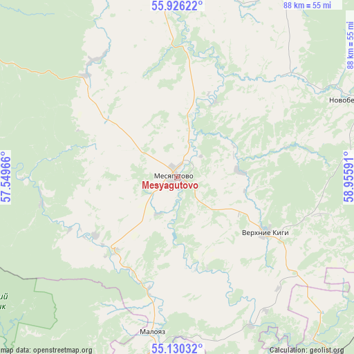
Mesyagutovo GPS coordinates[2]
55° 31' 49.008" North, 58° 15' 10.008" East
| Map corner | latitude | longitude |
|---|---|---|
| Upper-left | 55.92622°, | 57.54966° |
| Center: | 55.53028°, | 58.25278° |
| Lower-right: | 55.13032°, | 58.95591° |
| Map W x H: | 88.5×88.5 km | = 55×55mi |
| max Lat: | 73.50819° ⇑41.5% North |
| Mesyagutovo: | 55.53028° |
| min Lat: | ⇓58.5% South 41.28413° |
| min Long | Mesyagutovo | max Long |
| -179.12198° | 58.25278° | 179.35046° |
| W 69.8%⇐ | ⇒30.2% E |
Elevation
Elevation of Mesyagutovo is 212 m = 696 ft, and this is 9.4 m = 31 ft above average elevation for this country.
| Max E: |
2518 m = 8261 ft | 26% |
| Mesyagutovo | 212 m 696 ft | |
| Avg. | 202.6 m = 665 ft | |
Min E: |
-28 m = -92 ft | 74% |
See also: Russia elevation on elevation.city.
Geographical zone
Mesyagutovo is located in North temperate zone (between Tropic of Cancer and the Arctic Circle). Distance of this North polar circle is 1226.8 km =762.3 mi to North.| Distance of | km | miles | from Mesyagutovo |
|---|---|---|---|
| North Pole | 3832.7 | 2381.5 | to North |
| Arctic Circle | 1226.8 | 762.3 | to North |
| Tropic Cancer | 3568.5 | 2217.4 | to South |
| Equator | 6174.4 | 3836.6 | to South |


Nearby cities:
15 places around Mesyagutovo: (largest is in red/bold)
• Bakal
74.3 km =46.2 mi,  151°
151°
• Berdyaush
69.8 km =43.4 mi,  125°
125°
• Duvan
28.6 km =17.8 mi,  309°
309°
• Karayar
79.5 km =49.4 mi,  283°
283°
• Kropachëvo
60.1 km =37.3 mi,  196°
196°
• Kusa
77.9 km =48.4 mi,  105°
105°
• Mezhevoy
52.1 km =32.4 mi,  140°
140°
• Mursalimkino
58.1 km =36.1 mi,  160°
160°
• Novobelokatay
48.2 km =30 mi,  66°
66°
• Satka
73.7 km =45.8 mi, 137°
• Sim
69.3 km =43.1 mi,  210°
210°
• Ust’-Katav
66.2 km =41.1 mi,  184°
184°
• Verkhniye Kigi
26 km =16.2 mi,  121°
121°
• Vyazovaya
69.8 km =43.4 mi,  174°
174°
• Yuryuzan’
74.9 km =46.5 mi, 171°
Sources, notices
• [Note1] Compared only with cities in Russia existing in our database
• [Src1] Map data: © OpenStreetMap contributors (CC-BY-SA)
• [Src2] Other city data from geonames.org with taken over terms of usage.
• [Src3] Geographical zone / Annual Mean Temperature by Robert A. Rohde @ Wikipedia
