Kremenki geodata
Kremenki (Kaluga) is a populated place; located in Russia in Europe/Moscow (GMT+3) time zone. With population of 11,994 people, there are 1276 cities with bigger population in this country. Compared to other cities in Russia, 51.9% of cities are located further ↓South; 84.5% of cities are located further →East and 55.6% of cities have higher elevation than Kremenki. Note1


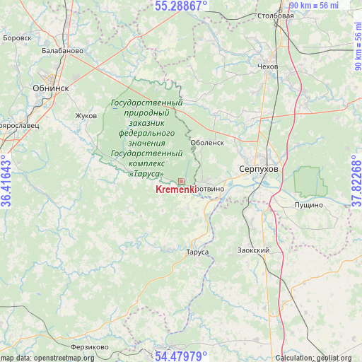
Kremenki GPS coordinates[2]
54° 53' 10.536" North, 37° 7' 10.38" East
| Map corner | latitude | longitude |
|---|---|---|
| Upper-left | 55.28867°, | 36.41643° |
| Center: | 54.88626°, | 37.11955° |
| Lower-right: | 54.47979°, | 37.82268° |
| Map W x H: | 89.9×89.9 km | = 55.9×55.9mi |
| max Lat: | 73.50819° ⇑48.1% North |
| Kremenki: | 54.88626° |
| min Lat: | ⇓51.9% South 41.28413° |
| min Long | Kremenki | max Long |
| -179.12198° | 37.11955° | 179.35046° |
| W 15.5%⇐ | ⇒84.5% E |
Elevation
Elevation of Kremenki is 133 m = 436 ft, and this is 69.6 m = 228 ft below average elevation for this country.
| Max E: |
2518 m = 8261 ft | 55.6% |
| Avg. | 202.6 m = 665 ft | |
| Kremenki | 133 m = 436 ft | |
Min E: |
-28 m = -92 ft | 44.4% |
See also: Russia elevation on elevation.city.
Geographical zone
Kremenki is located in North temperate zone (between Tropic of Cancer and the Arctic Circle). Distance of this North polar circle is 1298.4 km =806.8 mi to North.| Distance of | km | miles | from Kremenki |
|---|---|---|---|
| North Pole | 3904.3 | 2426 | to North |
| Arctic Circle | 1298.4 | 806.8 | to North |
| Tropic Cancer | 3496.9 | 2172.9 | to South |
| Equator | 6102.8 | 3792.1 | to South |


Nearby cities:
15 places around Kremenki: (largest is in red/bold)
• Belousovo
36.7 km =22.8 mi,  309°
309°
• Bol’shoye Gryzlovo
34.6 km =21.5 mi,  106°
106°
• Danki
29 km =18 mi,  83°
83°
• Obolensk
12.2 km =7.6 mi,  33°
33°
• Proletarskiy
23 km =14.3 mi,  48°
48°
• Protvino
6.5 km =4 mi, 108°
• Pushchino
32 km =19.9 mi,  100°
100°
• Raysemënovskoye
19.3 km =12 mi, 45°
• Serpukhov
18.9 km =11.7 mi, 80°
• Sharapova Okhota
28.5 km =17.7 mi, 53°
• Strakhovo
19.1 km =11.9 mi,  150°
150°
• Tarusa
18.3 km =11.4 mi,  169°
169°
• Vysokinichi
12.3 km =7.6 mi,  282°
282°
• Zaokskiy
25.1 km =15.6 mi,  133°
133°
• Zhukovo
28.9 km =18 mi,  304°
304°
Sources, notices
• [Note1] Compared only with cities in Russia existing in our database
• [Src1] Map data: © OpenStreetMap contributors (CC-BY-SA)
• [Src2] Other city data from geonames.org with taken over terms of usage.
• [Src3] Geographical zone / Annual Mean Temperature by Robert A. Rohde @ Wikipedia
