Kozlovo geodata
Kozlovo (Tver’ Oblast) is a populated place; located in Russia in Europe/Moscow (GMT+3) time zone. With population of 4,248 people, there are 2974 cities with bigger population in this country. Compared to other cities in Russia, 72.9% of cities are located further ↓South; 86.8% of cities are located further →East and 54.2% of cities have higher elevation than Kozlovo. Note1


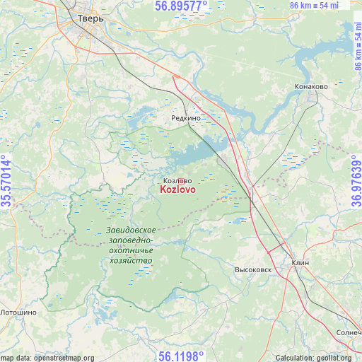
Kozlovo GPS coordinates[2]
56° 30' 35.172" North, 36° 16' 23.736" East
| Map corner | latitude | longitude |
|---|---|---|
| Upper-left | 56.89577°, | 35.57014° |
| Center: | 56.50977°, | 36.27326° |
| Lower-right: | 56.1198°, | 36.97639° |
| Map W x H: | 86.3×86.3 km | = 53.6×53.6mi |
| max Lat: | 73.50819° ⇑27.1% North |
| Kozlovo: | 56.50977° |
| min Lat: | ⇓72.9% South 41.28413° |
| min Long | Kozlovo | max Long |
| -179.12198° | 36.27326° | 179.35046° |
| W 13.2%⇐ | ⇒86.8% E |
Elevation
Elevation of Kozlovo is 136 m = 446 ft, and this is 66.6 m = 219 ft below average elevation for this country.
| Max E: |
2518 m = 8261 ft | 54.2% |
| Avg. | 202.6 m = 665 ft | |
| Kozlovo | 136 m = 446 ft | |
Min E: |
-28 m = -92 ft | 45.8% |
See also: Russia elevation on elevation.city.
Geographical zone
Kozlovo is located in North temperate zone (between Tropic of Cancer and the Arctic Circle). Distance of this North polar circle is 1117.9 km =694.6 mi to North.| Distance of | km | miles | from Kozlovo |
|---|---|---|---|
| North Pole | 3723.8 | 2313.9 | to North |
| Arctic Circle | 1117.9 | 694.6 | to North |
| Tropic Cancer | 3677.4 | 2285 | to South |
| Equator | 6283.3 | 3904.3 | to South |


Nearby cities:
15 places around Kozlovo: (largest is in red/bold)
• Emmaus
31.6 km =19.6 mi,  342°
342°
• Gorodnya
21.9 km =13.6 mi,  7°
7°
• Izoplit
13.3 km =8.3 mi,  346°
346°
• Klin
34.4 km =21.4 mi,  124°
124°
• Konakovo
36.9 km =22.9 mi,  54°
54°
• Novoshchapovo
35.7 km =22.2 mi, 115°
• Novozavidovskiy
10.8 km =6.7 mi,  65°
65°
• Radchenko
19.9 km =12.4 mi,  17°
17°
• Redkino
15.4 km =9.6 mi, 5°
• Reshetnikovo
19.2 km =11.9 mi,  110°
110°
• Shevlyakovo
38.1 km =23.7 mi, 109°
• Spas-Zaulok
18.2 km =11.3 mi,  99°
99°
• Teryayevo
38.9 km =24.2 mi,  193°
193°
• Vysokovsk
27.4 km =17 mi,  141°
141°
• Zavidovo
16.2 km =10.1 mi,  80°
80°
Sources, notices
• [Note1] Compared only with cities in Russia existing in our database
• [Src1] Map data: © OpenStreetMap contributors (CC-BY-SA)
• [Src2] Other city data from geonames.org with taken over terms of usage.
• [Src3] Geographical zone / Annual Mean Temperature by Robert A. Rohde @ Wikipedia
