Gorodnya geodata
Gorodnya (Tver’ Oblast) is a populated place; located in Russia in Europe/Moscow (GMT+3) time zone. With population of 5,000 people, there are 2658 cities with bigger population in this country. Compared to other cities in Russia, 74.5% of cities are located further ↓South; 86.7% of cities are located further →East and 50.8% of cities have lower elevation than Gorodnya. Note1


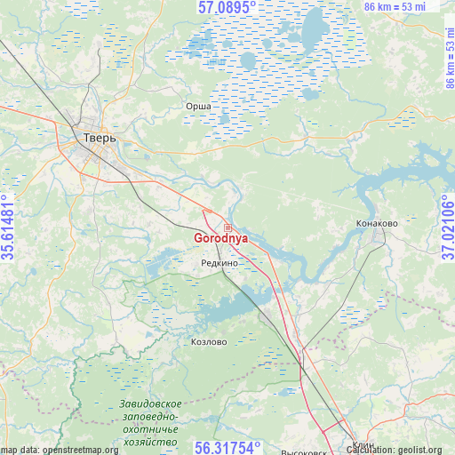
Gorodnya GPS coordinates[2]
56° 42' 19.8" North, 36° 19' 4.548" East
| Map corner | latitude | longitude |
|---|---|---|
| Upper-left | 57.0895°, | 35.61481° |
| Center: | 56.7055°, | 36.31793° |
| Lower-right: | 56.31754°, | 37.02106° |
| Map W x H: | 85.8×85.8 km | = 53.3×53.3mi |
| max Lat: | 73.50819° ⇑25.5% North |
| Gorodnya: | 56.7055° |
| min Lat: | ⇓74.5% South 41.28413° |
| min Long | Gorodnya | max Long |
| -179.12198° | 36.31793° | 179.35046° |
| W 13.3%⇐ | ⇒86.7% E |
Elevation
Elevation of Gorodnya is 146 m = 479 ft, and this is 56.6 m = 186 ft below average elevation for this country.
| Max E: |
2518 m = 8261 ft | 49.2% |
| Avg. | 202.6 m = 665 ft | |
| Gorodnya | 146 m = 479 ft | |
Min E: |
-28 m = -92 ft | 50.8% |
See also: Russia elevation on elevation.city.
Geographical zone
Gorodnya is located in North temperate zone (between Tropic of Cancer and the Arctic Circle). Distance of this North polar circle is 1096.1 km =681.1 mi to North.| Distance of | km | miles | from Gorodnya |
|---|---|---|---|
| North Pole | 3702 | 2300.3 | to North |
| Arctic Circle | 1096.1 | 681.1 | to North |
| Tropic Cancer | 3699.1 | 2298.5 | to South |
| Equator | 6305.1 | 3917.8 | to South |


Nearby cities:
15 places around Gorodnya: (largest is in red/bold)
• Emmaus
14.9 km =9.3 mi,  303°
303°
• Izoplit
10.6 km =6.6 mi,  213°
213°
• Konakovo
27.4 km =17 mi,  91°
91°
• Kozlovo
21.9 km =13.6 mi,  187°
187°
• Novozavidovskiy
18.7 km =11.6 mi,  157°
157°
• Orsha
23.6 km =14.7 mi,  346°
346°
• Radchenko
4.3 km =2.7 mi,  130°
130°
• Redkino
6.6 km =4.1 mi, 191°
• Reshetnikovo
32.2 km =20 mi,  151°
151°
• Sakharovo
27 km =16.8 mi,  322°
322°
• Spas-Zaulok
29 km =18 mi, 148°
• Tver
30.6 km =19 mi, 303°
• Vasil’yevskiy Mokh
41.9 km =26 mi, 324°
• Vysokovsk
45.5 km =28.3 mi, 161°
• Zavidovo
23.2 km =14.4 mi, 145°
Sources, notices
• [Note1] Compared only with cities in Russia existing in our database
• [Src1] Map data: © OpenStreetMap contributors (CC-BY-SA)
• [Src2] Other city data from geonames.org with taken over terms of usage.
• [Src3] Geographical zone / Annual Mean Temperature by Robert A. Rohde @ Wikipedia
