Reshetnikovo geodata
Reshetnikovo (Moscow Oblast) is a populated place; located in Russia in Europe/Moscow (GMT+3) time zone. With population of 3,192 people, there are 3614 cities with bigger population in this country. Compared to other cities in Russia, 72.2% of cities are located further ↓South; 86.1% of cities are located further →East and 52.4% of cities have lower elevation than Reshetnikovo. Note1


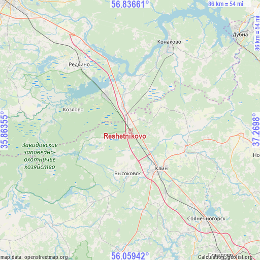
Reshetnikovo GPS coordinates[2]
56° 27' 0" North, 36° 34' 0.012" East
| Map corner | latitude | longitude |
|---|---|---|
| Upper-left | 56.83661°, | 35.86355° |
| Center: | 56.45°, | 36.56667° |
| Lower-right: | 56.05942°, | 37.2698° |
| Map W x H: | 86.4×86.4 km | = 53.7×53.7mi |
| max Lat: | 73.50819° ⇑27.8% North |
| Reshetnikovo: | 56.45° |
| min Lat: | ⇓72.2% South 41.28413° |
| min Long | Reshetnikovo | max Long |
| -179.12198° | 36.56667° | 179.35046° |
| W 13.9%⇐ | ⇒86.1% E |
Elevation
Elevation of Reshetnikovo is 150 m = 492 ft, and this is 52.6 m = 173 ft below average elevation for this country.
| Max E: |
2518 m = 8261 ft | 47.6% |
| Avg. | 202.6 m = 665 ft | |
| Reshetnikovo | 150 m = 492 ft | |
Min E: |
-28 m = -92 ft | 52.4% |
See also: Russia elevation on elevation.city.
Geographical zone
Reshetnikovo is located in North temperate zone (between Tropic of Cancer and the Arctic Circle). Distance of this North polar circle is 1124.5 km =698.7 mi to North.| Distance of | km | miles | from Reshetnikovo |
|---|---|---|---|
| North Pole | 3730.4 | 2318 | to North |
| Arctic Circle | 1124.5 | 698.7 | to North |
| Tropic Cancer | 3670.7 | 2280.9 | to South |
| Equator | 6276.7 | 3900.2 | to South |


Nearby cities:
15 places around Reshetnikovo: (largest is in red/bold)
• Gorodnya
32.2 km =20 mi,  331°
331°
• Izoplit
28.8 km =17.9 mi,  312°
312°
• Klin
16.5 km =10.3 mi,  141°
141°
• Konakovo
30.4 km =18.9 mi,  23°
23°
• Kozlovo
19.2 km =11.9 mi,  290°
290°
• Krivtsovo
38.7 km =24 mi,  149°
149°
• Novoshchapovo
16.7 km =10.4 mi,  120°
120°
• Novozavidovskiy
13.8 km =8.6 mi,  323°
323°
• Radchenko
28.3 km =17.6 mi, 334°
• Redkino
27.5 km =17.1 mi, 323°
• Rogachëvo
36.9 km =22.9 mi,  92°
92°
• Shevlyakovo
18.9 km =11.7 mi,  108°
108°
• Spas-Zaulok
3.7 km =2.3 mi,  0°
0°
• Vysokovsk
14.9 km =9.3 mi,  183°
183°
• Zavidovo
9.5 km =5.9 mi,  347°
347°
Sources, notices
• [Note1] Compared only with cities in Russia existing in our database
• [Src1] Map data: © OpenStreetMap contributors (CC-BY-SA)
• [Src2] Other city data from geonames.org with taken over terms of usage.
• [Src3] Geographical zone / Annual Mean Temperature by Robert A. Rohde @ Wikipedia
