Kostrovo geodata
Kostrovo (Moscow Oblast) is a populated place; located in Russia in Europe/Moscow (GMT+3) time zone. With population of 2,600 people, there are 3921 cities with bigger population in this country. Compared to other cities in Russia, 65.1% of cities are located further ↓South; 85.7% of cities are located further →East and 65.4% of cities have lower elevation than Kostrovo. Note1


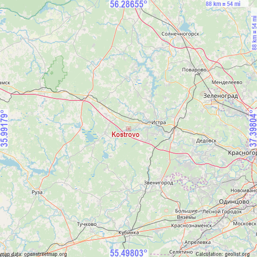
Kostrovo GPS coordinates[2]
55° 53' 39.444" North, 36° 41' 41.676" East
| Map corner | latitude | longitude |
|---|---|---|
| Upper-left | 56.28655°, | 35.99179° |
| Center: | 55.89429°, | 36.69491° |
| Lower-right: | 55.49803°, | 37.39804° |
| Map W x H: | 87.7×87.7 km | = 54.5×54.5mi |
| max Lat: | 73.50819° ⇑34.9% North |
| Kostrovo: | 55.89429° |
| min Lat: | ⇓65.1% South 41.28413° |
| min Long | Kostrovo | max Long |
| -179.12198° | 36.69491° | 179.35046° |
| W 14.3%⇐ | ⇒85.7% E |
Elevation
Elevation of Kostrovo is 183 m = 600 ft, and this is 19.6 m = 64 ft below average elevation for this country.
| Max E: |
2518 m = 8261 ft | 34.6% |
| Avg. | 202.6 m = 665 ft | |
| Kostrovo | 183 m = 600 ft | |
Min E: |
-28 m = -92 ft | 65.4% |
See also: Russia elevation on elevation.city.
Geographical zone
Kostrovo is located in North temperate zone (between Tropic of Cancer and the Arctic Circle). Distance of this North polar circle is 1186.3 km =737.1 mi to North.| Distance of | km | miles | from Kostrovo |
|---|---|---|---|
| North Pole | 3792.2 | 2356.4 | to North |
| Arctic Circle | 1186.3 | 737.1 | to North |
| Tropic Cancer | 3608.9 | 2242.5 | to South |
| Equator | 6214.9 | 3861.8 | to South |


Nearby cities:
15 places around Kostrovo: (largest is in red/bold)
• Andreyevka
29 km =18 mi,  70°
70°
• Dedovsk
26.8 km =16.7 mi,  96°
96°
• Istra
11.2 km =7 mi,  75°
75°
• Karinskoye
20.5 km =12.7 mi,  181°
181°
• Kolyubakino
27.1 km =16.8 mi,  201°
201°
• Nikolina Gora
28.1 km =17.5 mi,  129°
129°
• Novopetrovskoye
17.7 km =11 mi,  308°
308°
• Nudol’
25.4 km =15.8 mi,  334°
334°
• Pavlovskaya Sloboda
25.7 km =16 mi,  109°
109°
• Rozhdestveno
22.5 km =14 mi, 101°
• Rumyantsevo
13.3 km =8.3 mi, 311°
• Savvinskaya Sloboda
20.2 km =12.6 mi,  160°
160°
• Snegiri
20.5 km =12.7 mi,  91°
91°
• Yershovo
17.3 km =10.7 mi,  143°
143°
• Zvenigorod
20.6 km =12.8 mi,  150°
150°
Sources, notices
• [Note1] Compared only with cities in Russia existing in our database
• [Src1] Map data: © OpenStreetMap contributors (CC-BY-SA)
• [Src2] Other city data from geonames.org with taken over terms of usage.
• [Src3] Geographical zone / Annual Mean Temperature by Robert A. Rohde @ Wikipedia
