Kostino geodata
Kostino (Kirov) is a populated place; located in Russia in Europe/Kirov (GMT+3) time zone. With population of 3,466 people, there are 3421 cities with bigger population in this country. Compared to other cities in Russia, 86.3% of cities are located further ↓South; 65% of cities are located further ←West and 69.8% of cities have lower elevation than Kostino. Note1


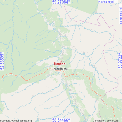
Kostino GPS coordinates[2]
58° 54' 34.776" North, 53° 16' 8.652" East
| Map corner | latitude | longitude |
|---|---|---|
| Upper-left | 59.27084°, | 52.56595° |
| Center: | 58.90966°, | 53.26907° |
| Lower-right: | 58.54466°, | 53.9722° |
| Map W x H: | 80.7×80.7 km | = 50.1×50.1mi |
| max Lat: | 73.50819° ⇑13.7% North |
| Kostino: | 58.90966° |
| min Lat: | ⇓86.3% South 41.28413° |
| min Long | Kostino | max Long |
| -179.12198° | 53.26907° | 179.35046° |
| W 65%⇐ | ⇒35% E |
Elevation
Elevation of Kostino is 197 m = 646 ft, and this is 5.6 m = 18 ft below average elevation for this country.
| Max E: |
2518 m = 8261 ft | 30.2% |
| Avg. | 202.6 m = 665 ft | |
| Kostino | 197 m = 646 ft | |
Min E: |
-28 m = -92 ft | 69.8% |
See also: Russia elevation on elevation.city.
Geographical zone
Kostino is located in North temperate zone (between Tropic of Cancer and the Arctic Circle). Distance of this North polar circle is 851 km =528.8 mi to North.| Distance of | km | miles | from Kostino |
|---|---|---|---|
| North Pole | 3456.9 | 2148 | to North |
| Arctic Circle | 851 | 528.8 | to North |
| Tropic Cancer | 3944.2 | 2450.8 | to South |
| Equator | 6550.1 | 4070 | to South |


Nearby cities:
15 places around Kostino: (largest is in red/bold)
• Belorechensk
58.2 km =36.2 mi,  254°
254°
• Chërnaya Kholunitsa
89.5 km =55.6 mi,  265°
265°
• Glazov
92.7 km =57.6 mi,  202°
202°
• Kirs
75.5 km =46.9 mi,  309°
309°
• Kochevo
96.9 km =60.2 mi,  37°
37°
• Kudymkar
80.3 km =49.9 mi,  81°
81°
• Lesnyye Polyany
49.9 km =31 mi,  282°
282°
• Omutninsk
67.5 km =41.9 mi, 246°
• Peskovka
54.2 km =33.7 mi,  286°
286°
• Pudem
92.7 km =57.6 mi,  223°
223°
• Rudnichnyy
90.8 km =56.4 mi,  330°
330°
• Siva
87 km =54.1 mi,  132°
132°
• Svetlopolyansk
76.7 km =47.7 mi,  317°
317°
• Vostochnyy
60.4 km =37.5 mi,  257°
257°
• Yurla
76.1 km =47.3 mi,  52°
52°
Sources, notices
• [Note1] Compared only with cities in Russia existing in our database
• [Src1] Map data: © OpenStreetMap contributors (CC-BY-SA)
• [Src2] Other city data from geonames.org with taken over terms of usage.
• [Src3] Geographical zone / Annual Mean Temperature by Robert A. Rohde @ Wikipedia
