Alnashi geodata
Alnashi (Udmurtiya Republic) is a populated place; located in Russia in Europe/Samara (GMT+4) time zone. With population of 6,205 people, there are 2204 cities with bigger population in this country. Compared to other cities in Russia, 69.2% of cities are located further ↓South; 64.5% of cities are located further ←West and 62% of cities have higher elevation than Alnashi. Note1


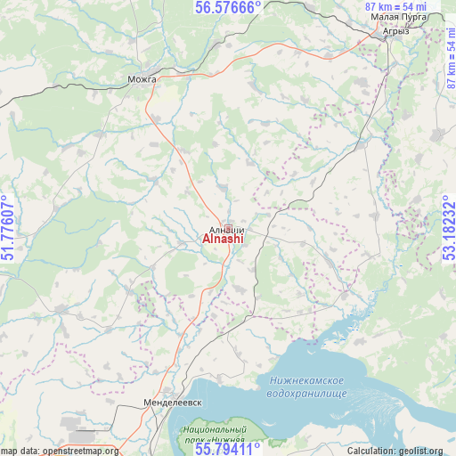
Alnashi GPS coordinates[2]
56° 11' 14.568" North, 52° 28' 45.084" East
| Map corner | latitude | longitude |
|---|---|---|
| Upper-left | 56.57666°, | 51.77607° |
| Center: | 56.18738°, | 52.47919° |
| Lower-right: | 55.79411°, | 53.18232° |
| Map W x H: | 87×87 km | = 54.1×54.1mi |
| max Lat: | 73.50819° ⇑30.8% North |
| Alnashi: | 56.18738° |
| min Lat: | ⇓69.2% South 41.28413° |
| min Long | Alnashi | max Long |
| -179.12198° | 52.47919° | 179.35046° |
| W 64.5%⇐ | ⇒35.5% E |
Elevation
Elevation of Alnashi is 120 m = 394 ft, and this is 82.6 m = 271 ft below average elevation for this country.
| Max E: |
2518 m = 8261 ft | 62% |
| Avg. | 202.6 m = 665 ft | |
| Alnashi | 120 m = 394 ft | |
Min E: |
-28 m = -92 ft | 38% |
See also: Russia elevation on elevation.city.
Geographical zone
Alnashi is located in North temperate zone (between Tropic of Cancer and the Arctic Circle). Distance of this North polar circle is 1153.7 km =716.9 mi to North.| Distance of | km | miles | from Alnashi |
|---|---|---|---|
| North Pole | 3759.6 | 2336.1 | to North |
| Arctic Circle | 1153.7 | 716.9 | to North |
| Tropic Cancer | 3641.5 | 2262.7 | to South |
| Equator | 6247.5 | 3882 | to South |


Nearby cities:
15 places around Alnashi: (largest is in red/bold)
• Agryz
48.8 km =30.3 mi,  40°
40°
• Grakhovo
35.2 km =21.9 mi,  244°
244°
• Kiyasovo
43.7 km =27.2 mi,  65°
65°
• Kizner
60.8 km =37.8 mi,  279°
279°
• Lubyany
68.9 km =42.8 mi,  256°
256°
• Malaya Purga
52.3 km =32.5 mi, 38°
• Mendeleyevsk
33.2 km =20.6 mi,  200°
200°
• Menzelinsk
64.2 km =39.9 mi,  142°
142°
• Mozhga
32.5 km =20.2 mi,  331°
331°
• Naberezhnyye Chelny
51.5 km =32 mi,  184°
184°
• Nizhnekamsk
73.6 km =45.7 mi,  213°
213°
• Pychas
35.2 km =21.9 mi,  356°
356°
• Sosnovka
74.3 km =46.2 mi, 275°
• Vavozh
73.5 km =45.7 mi, 332°
• Yelabuga
53.9 km =33.5 mi, 208°
Sources, notices
• [Note1] Compared only with cities in Russia existing in our database
• [Src1] Map data: © OpenStreetMap contributors (CC-BY-SA)
• [Src2] Other city data from geonames.org with taken over terms of usage.
• [Src3] Geographical zone / Annual Mean Temperature by Robert A. Rohde @ Wikipedia
