Kinel’ geodata
Kinel’ (Samara Oblast) is a populated place; located in Russia in Europe/Samara (GMT+4) time zone. With population of 34,336 people, there are 587 cities with bigger population in this country. Compared to other cities in Russia, 61.2% of cities are located further ↑North; 62.7% of cities are located further ←West and 87.5% of cities have higher elevation than Kinel’. Note1


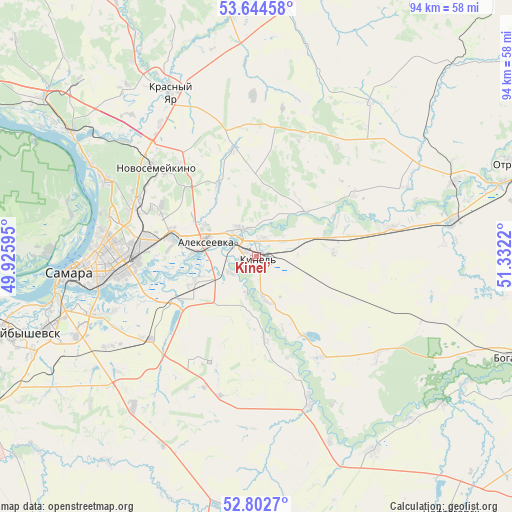
Kinel’ GPS coordinates[2]
53° 13' 32.556" North, 50° 37' 44.652" East
| Map corner | latitude | longitude |
|---|---|---|
| Upper-left | 53.64458°, | 49.92595° |
| Center: | 53.22571°, | 50.62907° |
| Lower-right: | 52.8027°, | 51.3322° |
| Map W x H: | 93.6×93.6 km | = 58.2×58.2mi |
| max Lat: | 73.50819° ⇑61.2% North |
| Kinel’: | 53.22571° |
| min Lat: | ⇓38.8% South 41.28413° |
| min Long | Kinel’ | max Long |
| -179.12198° | 50.62907° | 179.35046° |
| W 62.7%⇐ | ⇒37.3% E |
Elevation
Elevation of Kinel’ is 38 m = 125 ft, and this is 164.6 m = 540 ft below average elevation for this country.
| Max E: |
2518 m = 8261 ft | 87.5% |
| Avg. | 202.6 m = 665 ft | |
| Kinel’ | 38 m = 125 ft | |
Min E: |
-28 m = -92 ft | 12.5% |
See also: Russia elevation on elevation.city.
Geographical zone
Kinel’ is located in North temperate zone (between Tropic of Cancer and the Arctic Circle). Distance of this North polar circle is 1483 km =921.5 mi to North.| Distance of | km | miles | from Kinel’ |
|---|---|---|---|
| North Pole | 4088.9 | 2540.7 | to North |
| Arctic Circle | 1483 | 921.5 | to North |
| Tropic Cancer | 3312.2 | 2058.1 | to South |
| Equator | 5918.1 | 3677.3 | to South |


Nearby cities:
15 places around Kinel’: (largest is in red/bold)
• Berëza
46 km =28.6 mi,  315°
315°
• Dubovyy Umët
36 km =22.4 mi,  219°
219°
• Georgiyevka
25.2 km =15.7 mi,  77°
77°
• Krasnyy Yar
34.3 km =21.3 mi,  332°
332°
• Krotovka
36.5 km =22.7 mi, 79°
• Mirnyy
39 km =24.2 mi, 323°
• Novosemeykino
24.3 km =15.1 mi,  311°
311°
• Petra-Dubrava
19.2 km =11.9 mi,  294°
294°
• Roschinskiy
21.3 km =13.2 mi,  204°
204°
• Rozhdestveno
37.9 km =23.5 mi,  271°
271°
• Samara
32 km =19.9 mi,  264°
264°
• Smyshlyayevka
15.9 km =9.9 mi,  275°
275°
• Spiridonovka
14.9 km =9.3 mi,  175°
175°
• Utevka
41.7 km =25.9 mi,  149°
149°
• Volzhskiy
40.8 km =25.4 mi,  303°
303°
Sources, notices
• [Note1] Compared only with cities in Russia existing in our database
• [Src1] Map data: © OpenStreetMap contributors (CC-BY-SA)
• [Src2] Other city data from geonames.org with taken over terms of usage.
• [Src3] Geographical zone / Annual Mean Temperature by Robert A. Rohde @ Wikipedia
