Petra-Dubrava geodata
Petra-Dubrava (Samara Oblast) is a populated place; located in Russia in Europe/Samara (GMT+4) time zone. With population of 6,078 people, there are 2232 cities with bigger population in this country. Compared to other cities in Russia, 60.4% of cities are located further ↑North; 62.5% of cities are located further ←West and 51.5% of cities have lower elevation than Petra-Dubrava. Note1


Petra-Dubrava GPS coordinates[2]
53° 17' 46.068" North, 50° 21' 55.944" East
| Map corner | latitude | longitude |
|---|---|---|
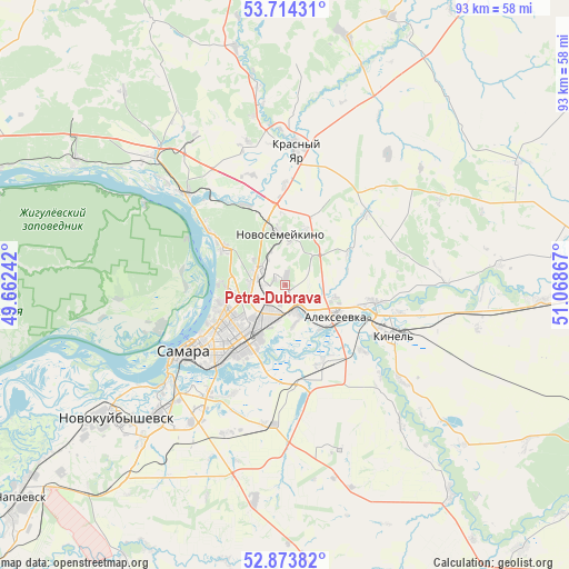
| Upper-left | 53.71431°, | 49.66242° |
| Center: | 53.29613°, | 50.36554° |
| Lower-right: | 52.87382°, | 51.06867° |
| Map W x H: | 93.5×93.5 km | = 58.1×58.1mi |
| max Lat: | 73.50819° ⇑60.4% North |
| Petra-Dubrava: | 53.29613° |
| min Lat: | ⇓39.6% South 41.28413° |
| min Long | Petra-Dubrava | max Long |
| -179.12198° | 50.36554° | 179.35046° |
| W 62.5%⇐ | ⇒37.5% E |
Elevation
Elevation of Petra-Dubrava is 148 m = 486 ft, and this is 54.6 m = 179 ft below average elevation for this country.
| Max E: |
2518 m = 8261 ft | 48.5% |
| Avg. | 202.6 m = 665 ft | |
| Petra-Dubrava | 148 m = 486 ft | |
Min E: |
-28 m = -92 ft | 51.5% |
See also: Russia elevation on elevation.city.
Geographical zone
Petra-Dubrava is located in North temperate zone (between Tropic of Cancer and the Arctic Circle). Distance of this North polar circle is 1475.2 km =916.6 mi to North.| Distance of | km | miles | from Petra-Dubrava |
|---|---|---|---|
| North Pole | 4081.1 | 2535.9 | to North |
| Arctic Circle | 1475.2 | 916.6 | to North |
| Tropic Cancer | 3320.1 | 2063 | to South |
| Equator | 5926 | 3682.2 | to South |


Nearby cities:
15 places around Petra-Dubrava: (largest is in red/bold)
• Berëza
28.9 km =18 mi,  328°
328°
• Bogatyr’
31.6 km =19.6 mi,  298°
298°
• Dubovyy Umët
36 km =22.4 mi,  188°
188°
• Kinel’
19.2 km =11.9 mi,  114°
114°
• Krasnyy Yar
22.7 km =14.1 mi,  4°
4°
• Kurumoch
30.6 km =19 mi,  314°
314°
• Mirnyy
24.1 km =15 mi,  345°
345°
• Novokuybyshevsk
35.7 km =22.2 mi,  231°
231°
• Novosemeykino
8.3 km =5.2 mi, 354°
• Roschinskiy
28.6 km =17.8 mi,  162°
162°
• Rozhdestveno
21.4 km =13.3 mi,  252°
252°
• Samara
17.9 km =11.1 mi, 233°
• Smyshlyayevka
6.6 km =4.1 mi,  165°
165°
• Spiridonovka
29.4 km =18.3 mi,  140°
140°
• Volzhskiy
22.2 km =13.8 mi, 312°
Sources, notices
• [Note1] Compared only with cities in Russia existing in our database
• [Src1] Map data: © OpenStreetMap contributors (CC-BY-SA)
• [Src2] Other city data from geonames.org with taken over terms of usage.
• [Src3] Geographical zone / Annual Mean Temperature by Robert A. Rohde @ Wikipedia
