Samara geodata
Samara (Samara Oblast) is a seat of a first-order administrative division; located in Russia in Europe/Samara (GMT+4) time zone. With population of 1,134,730 people, there are 5 cities with bigger population in this country. Compared to other cities in Russia, 61.5% of cities are located further ↑North; 62.3% of cities are located further ←West and 63.5% of cities have higher elevation than Samara. Note1


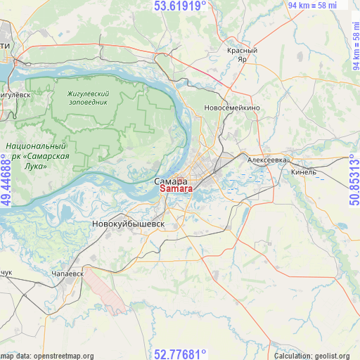
Samara GPS coordinates[2]
53° 12' 0.252" North, 50° 9' 0" East
| Map corner | latitude | longitude |
|---|---|---|
| Upper-left | 53.61919°, | 49.44688° |
| Center: | 53.20007°, | 50.15° |
| Lower-right: | 52.77681°, | 50.85313° |
| Map W x H: | 93.7×93.7 km | = 58.2×58.2mi |
| max Lat: | 73.50819° ⇑61.5% North |
| Samara: | 53.20007° |
| min Lat: | ⇓38.5% South 41.28413° |
| min Long | Samara | max Long |
| -179.12198° | 50.15° | 179.35046° |
| W 62.3%⇐ | ⇒37.7% E |
Elevation
Elevation of Samara is 117 m = 384 ft, and this is 85.6 m = 281 ft below average elevation for this country.
| Max E: |
2518 m = 8261 ft | 63.5% |
| Avg. | 202.6 m = 665 ft | |
| Samara | 117 m = 384 ft | |
Min E: |
-28 m = -92 ft | 36.5% |
See also: Samara elevation on elevation.city.
Geographical zone
Samara is located in North temperate zone (between Tropic of Cancer and the Arctic Circle). Distance of this North polar circle is 1485.9 km =923.3 mi to North.| Distance of | km | miles | from Samara |
|---|---|---|---|
| North Pole | 4091.8 | 2542.5 | to North |
| Arctic Circle | 1485.9 | 923.3 | to North |
| Tropic Cancer | 3309.4 | 2056.4 | to South |
| Equator | 5915.3 | 3675.6 | to South |


Nearby cities:
15 places around Samara: (largest is in red/bold)
• Berëza
35.4 km =22 mi,  358°
358°
• Bogatyr’
28.9 km =18 mi,  331°
331°
• Dubovyy Umët
26.5 km =16.5 mi,  159°
159°
• Kinel’
32 km =19.9 mi,  84°
84°
• Kurumoch
33.1 km =20.6 mi,  346°
346°
• Mirnyy
35.1 km =21.8 mi,  13°
13°
• Novokuybyshevsk
17.9 km =11.1 mi,  229°
229°
• Novosemeykino
23.3 km =14.5 mi,  35°
35°
• Petra-Dubrava
17.9 km =11.1 mi,  53°
53°
• Roschinskiy
28.4 km =17.6 mi,  125°
125°
• Rozhdestveno
7.3 km =4.5 mi,  304°
304°
• Smyshlyayevka
16.6 km =10.3 mi,  74°
74°
• Spiridonovka
35.2 km =21.9 mi,  109°
109°
• Volzhskiy
25.7 km =16 mi, 355°
• Zol’noye
35.7 km =22.2 mi,  319°
319°
Sources, notices
• [Note1] Compared only with cities in Russia existing in our database
• [Src1] Map data: © OpenStreetMap contributors (CC-BY-SA)
• [Src2] Other city data from geonames.org with taken over terms of usage.
• [Src3] Geographical zone / Annual Mean Temperature by Robert A. Rohde @ Wikipedia
