Krotovka geodata
Krotovka (Samara Oblast) is a populated place; located in Russia in Europe/Samara (GMT+4) time zone. With population of 5,398 people, there are 2474 cities with bigger population in this country. Compared to other cities in Russia, 60.4% of cities are located further ↑North; 63.2% of cities are located further ←West and 86.7% of cities have higher elevation than Krotovka. Note1


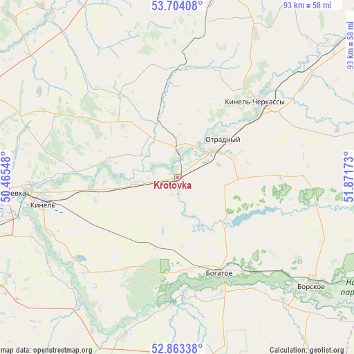
Krotovka GPS coordinates[2]
53° 17' 8.88" North, 51° 10' 6.96" East
| Map corner | latitude | longitude |
|---|---|---|
| Upper-left | 53.70408°, | 50.46548° |
| Center: | 53.2858°, | 51.1686° |
| Lower-right: | 52.86338°, | 51.87173° |
| Map W x H: | 93.5×93.5 km | = 58.1×58.1mi |
| max Lat: | 73.50819° ⇑60.4% North |
| Krotovka: | 53.2858° |
| min Lat: | ⇓39.6% South 41.28413° |
| min Long | Krotovka | max Long |
| -179.12198° | 51.1686° | 179.35046° |
| W 63.2%⇐ | ⇒36.8% E |
Elevation
Elevation of Krotovka is 41 m = 135 ft, and this is 161.6 m = 530 ft below average elevation for this country.
| Max E: |
2518 m = 8261 ft | 86.7% |
| Avg. | 202.6 m = 665 ft | |
| Krotovka | 41 m = 135 ft | |
Min E: |
-28 m = -92 ft | 13.3% |
See also: Russia elevation on elevation.city.
Geographical zone
Krotovka is located in North temperate zone (between Tropic of Cancer and the Arctic Circle). Distance of this North polar circle is 1476.3 km =917.3 mi to North.| Distance of | km | miles | from Krotovka |
|---|---|---|---|
| North Pole | 4082.2 | 2536.6 | to North |
| Arctic Circle | 1476.3 | 917.3 | to North |
| Tropic Cancer | 3318.9 | 2062.3 | to South |
| Equator | 5924.8 | 3681.5 | to South |


Nearby cities:
15 places around Krotovka: (largest is in red/bold)
• Bogatoye
27.4 km =17 mi,  156°
156°
• Borskoye
46.1 km =28.6 mi,  127°
127°
• Georgiyevka
11.4 km =7.1 mi,  263°
263°
• Kinel’
36.5 km =22.7 mi, 259°
• Kinel’-Cherkassy
28.9 km =18 mi,  44°
44°
• Krasnyy Yar
56.7 km =35.2 mi,  294°
294°
• Neftegorsk
53.8 km =33.4 mi,  180°
180°
• Novosemeykino
54.9 km =34.1 mi,  279°
279°
• Otradnyy
15.4 km =9.6 mi,  49°
49°
• Petra-Dubrava
53.4 km =33.2 mi,  271°
271°
• Podsolnechnoye
58.6 km =36.4 mi,  104°
104°
• Roschinskiy
51.8 km =32.2 mi,  239°
239°
• Smyshlyayevka
52 km =32.3 mi, 264°
• Spiridonovka
40.9 km =25.4 mi, 238°
• Utevka
45 km =28 mi,  198°
198°
Sources, notices
• [Note1] Compared only with cities in Russia existing in our database
• [Src1] Map data: © OpenStreetMap contributors (CC-BY-SA)
• [Src2] Other city data from geonames.org with taken over terms of usage.
• [Src3] Geographical zone / Annual Mean Temperature by Robert A. Rohde @ Wikipedia
