Kashirskoye geodata
Kashirskoye (Voronezj) is a populated place; located in Russia in Europe/Moscow (GMT+3) time zone. With population of 4,564 people, there are 2842 cities with bigger population in this country. Compared to other cities in Russia, 72.9% of cities are located further ↑North; 69.5% of cities are located further →East and 56.6% of cities have higher elevation than Kashirskoye. Note1


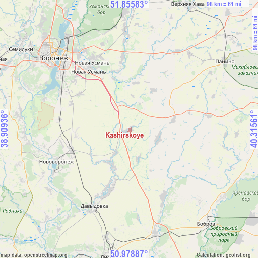
Kashirskoye GPS coordinates[2]
51° 25' 10.02" North, 39° 36' 44.928" East
| Map corner | latitude | longitude |
|---|---|---|
| Upper-left | 51.85583°, | 38.90936° |
| Center: | 51.41945°, | 39.61248° |
| Lower-right: | 50.97887°, | 40.31561° |
| Map W x H: | 97.5×97.5 km | = 60.6×60.6mi |
| max Lat: | 73.50819° ⇑72.9% North |
| Kashirskoye: | 51.41945° |
| min Lat: | ⇓27.1% South 41.28413° |
| min Long | Kashirskoye | max Long |
| -179.12198° | 39.61248° | 179.35046° |
| W 30.5%⇐ | ⇒69.5% E |
Elevation
Elevation of Kashirskoye is 131 m = 430 ft, and this is 71.6 m = 235 ft below average elevation for this country.
| Max E: |
2518 m = 8261 ft | 56.6% |
| Avg. | 202.6 m = 665 ft | |
| Kashirskoye | 131 m = 430 ft | |
Min E: |
-28 m = -92 ft | 43.4% |
See also: Russia elevation on elevation.city.
Geographical zone
Kashirskoye is located in North temperate zone (between Tropic of Cancer and the Arctic Circle). Distance of this North polar circle is 1683.9 km =1046.3 mi to North.| Distance of | km | miles | from Kashirskoye |
|---|---|---|---|
| North Pole | 4289.8 | 2665.6 | to North |
| Arctic Circle | 1683.9 | 1046.3 | to North |
| Tropic Cancer | 3111.4 | 1933.3 | to South |
| Equator | 5717.3 | 3552.6 | to South |


Nearby cities:
15 places around Kashirskoye: (largest is in red/bold)
• Davydovka
31.8 km =19.8 mi,  203°
203°
• Drakino
34.4 km =21.4 mi,  205°
205°
• Kolodeznyy
31.3 km =19.4 mi,  252°
252°
• Kostenki
40.1 km =24.9 mi,  265°
265°
• Maslovka
30 km =18.6 mi,  299°
299°
• Novaya Usman’
28.5 km =17.7 mi,  330°
330°
• Novovoronezh
30.1 km =18.7 mi, 245°
• Orlovo
37.2 km =23.1 mi,  357°
357°
• Panino
44.1 km =27.4 mi,  55°
55°
• Podkletnoye
21.6 km =13.4 mi, 331°
• Shilovo
38.9 km =24.2 mi,  291°
291°
• Somovo
39.6 km =24.6 mi, 334°
• Sredniy Ikorets
40.4 km =25.1 mi,  165°
165°
• Volya
38.8 km =24.1 mi,  352°
352°
• Voronezh
40.8 km =25.4 mi,  313°
313°
Sources, notices
• [Note1] Compared only with cities in Russia existing in our database
• [Src1] Map data: © OpenStreetMap contributors (CC-BY-SA)
• [Src2] Other city data from geonames.org with taken over terms of usage.
• [Src3] Geographical zone / Annual Mean Temperature by Robert A. Rohde @ Wikipedia
