Drakino geodata
Drakino (Voronezj) is a populated place; located in Russia in Europe/Moscow (GMT+3) time zone. With population of 3,071 people, there are 3719 cities with bigger population in this country. Compared to other cities in Russia, 74.3% of cities are located further ↑North; 70.5% of cities are located further →East and 73.8% of cities have higher elevation than Drakino. Note1


Drakino GPS coordinates[2]
51° 8' 20.328" North, 39° 24' 7.74" East
| Map corner | latitude | longitude |
|---|---|---|
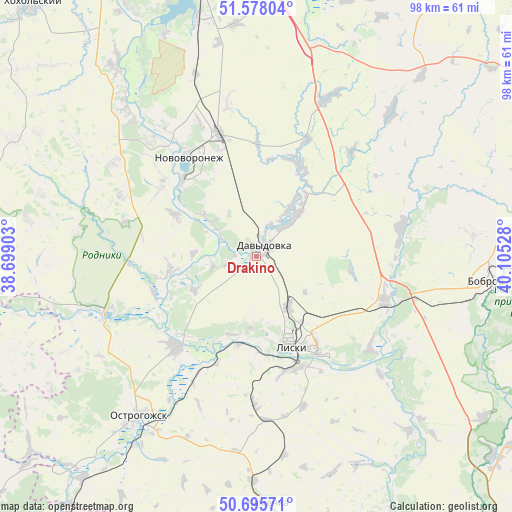
| Upper-left | 51.57804°, | 38.69903° |
| Center: | 51.13898°, | 39.40215° |
| Lower-right: | 50.69571°, | 40.10528° |
| Map W x H: | 98.1×98.1 km | = 61×61mi |
| max Lat: | 73.50819° ⇑74.3% North |
| Drakino: | 51.13898° |
| min Lat: | ⇓25.7% South 41.28413° |
| min Long | Drakino | max Long |
| -179.12198° | 39.40215° | 179.35046° |
| W 29.5%⇐ | ⇒70.5% E |
Elevation
Elevation of Drakino is 92 m = 302 ft, and this is 110.6 m = 363 ft below average elevation for this country.
| Max E: |
2518 m = 8261 ft | 73.8% |
| Avg. | 202.6 m = 665 ft | |
| Drakino | 92 m = 302 ft | |
Min E: |
-28 m = -92 ft | 26.2% |
See also: Russia elevation on elevation.city.
Geographical zone
Drakino is located in North temperate zone (between Tropic of Cancer and the Arctic Circle). Distance of this North polar circle is 1715.1 km =1065.7 mi to North.| Distance of | km | miles | from Drakino |
|---|---|---|---|
| North Pole | 4320.9 | 2684.9 | to North |
| Arctic Circle | 1715.1 | 1065.7 | to North |
| Tropic Cancer | 3080.2 | 1913.9 | to South |
| Equator | 5686.1 | 3533.2 | to South |


Nearby cities:
15 places around Drakino: (largest is in red/bold)
• Bobrov
44.3 km =27.5 mi,  96°
96°
• Davydovka
2.8 km =1.7 mi,  41°
41°
• Imeni Pervogo Maya
30.7 km =19.1 mi,  154°
154°
• Kamenka
47.2 km =29.3 mi,  178°
178°
• Kashirskoye
34.4 km =21.4 mi,  25°
25°
• Kolodeznyy
26.4 km =16.4 mi,  324°
324°
• Korotoyak
23.1 km =14.4 mi,  222°
222°
• Kostenki
38 km =23.6 mi, 317°
• Liski
19 km =11.8 mi,  155°
155°
• Maslovka
47.5 km =29.5 mi,  345°
345°
• Novovoronezh
22.7 km =14.1 mi,  325°
325°
• Ostrogozhsk
38 km =23.6 mi, 217°
• Shilovo
50.2 km =31.2 mi, 334°
• Sredniy Ikorets
26.1 km =16.2 mi,  107°
107°
• Uryv-Pokrovka
16.8 km =10.4 mi,  261°
261°
Sources, notices
• [Note1] Compared only with cities in Russia existing in our database
• [Src1] Map data: © OpenStreetMap contributors (CC-BY-SA)
• [Src2] Other city data from geonames.org with taken over terms of usage.
• [Src3] Geographical zone / Annual Mean Temperature by Robert A. Rohde @ Wikipedia
