Kamenka geodata
Kamenka (Voronezj) is a populated place; located in Russia in Europe/Moscow (GMT+3) time zone. With population of 9,450 people, there are 1597 cities with bigger population in this country. Compared to other cities in Russia, 73.4% of cities are located further ↑North; 57.5% of cities are located further →East and 54.5% of cities have lower elevation than Kamenka. Note1


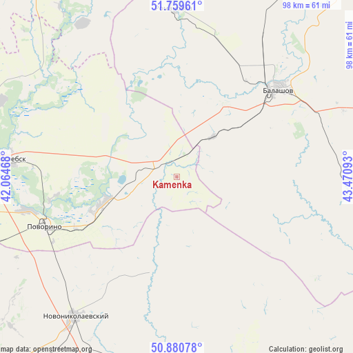
Kamenka GPS coordinates[2]
51° 19' 20.28" North, 42° 46' 4.08" East
| Map corner | latitude | longitude |
|---|---|---|
| Upper-left | 51.75961°, | 42.06468° |
| Center: | 51.3223°, | 42.7678° |
| Lower-right: | 50.88078°, | 43.47093° |
| Map W x H: | 97.7×97.7 km | = 60.7×60.7mi |
| max Lat: | 73.50819° ⇑73.4% North |
| Kamenka: | 51.3223° |
| min Lat: | ⇓26.6% South 41.28413° |
| min Long | Kamenka | max Long |
| -179.12198° | 42.7678° | 179.35046° |
| W 42.5%⇐ | ⇒57.5% E |
Elevation
Elevation of Kamenka is 155 m = 509 ft, and this is 47.6 m = 156 ft below average elevation for this country.
| Max E: |
2518 m = 8261 ft | 45.5% |
| Avg. | 202.6 m = 665 ft | |
| Kamenka | 155 m = 509 ft | |
Min E: |
-28 m = -92 ft | 54.5% |
See also: Russia elevation on elevation.city.
Geographical zone
Kamenka is located in North temperate zone (between Tropic of Cancer and the Arctic Circle). Distance of this North polar circle is 1694.7 km =1053 mi to North.| Distance of | km | miles | from Kamenka |
|---|---|---|---|
| North Pole | 4300.6 | 2672.3 | to North |
| Arctic Circle | 1694.7 | 1053 | to North |
| Tropic Cancer | 3100.6 | 1926.6 | to South |
| Equator | 5706.5 | 3545.9 | to South |


Nearby cities:
15 places around Kamenka: (largest is in red/bold)
• Balashov
37.5 km =23.3 mi,  47°
47°
• Bol’shoy Karay
31.9 km =19.8 mi,  350°
350°
• Borisoglebsk
47.7 km =29.6 mi,  275°
275°
• Gribanovskiy
56.9 km =35.4 mi,  285°
285°
• Kikvidze
67.6 km =42 mi,  162°
162°
• Muchkapskiy
62.3 km =38.7 mi,  340°
340°
• Novonikolayevskiy
47.9 km =29.8 mi,  215°
215°
• Pinerovka
33.8 km =21 mi,  38°
38°
• Povorino
39 km =24.2 mi,  248°
248°
• Repnoye
41.7 km =25.9 mi, 44°
• Romanovka
46.9 km =29.1 mi,  358°
358°
• Samoylovka
67.2 km =41.8 mi,  103°
103°
• Uryupinsk
78 km =48.5 mi, 222°
• Uvarovo
81.5 km =50.6 mi,  334°
334°
• Yelan’
79.4 km =49.3 mi,  121°
121°
Sources, notices
• [Note1] Compared only with cities in Russia existing in our database
• [Src1] Map data: © OpenStreetMap contributors (CC-BY-SA)
• [Src2] Other city data from geonames.org with taken over terms of usage.
• [Src3] Geographical zone / Annual Mean Temperature by Robert A. Rohde @ Wikipedia
